
Saint-Michel (Gers)
|
Saint-Michel Sent Miquèu |
||
|---|---|---|
|
||
| region | Occitania | |
| Department | Gers | |
| Arrondissement | Mirande | |
| Canton | Mirande-Astarac | |
| Community association | Astarac Arros en Gascogne | |
| Coordinates | 43 ° 26 ' N , 0 ° 25' E | |
| height | 168-286 m | |
| surface | 16.56 km 2 | |
| Residents | 253 (January 1, 2017) | |
| Population density | 15 inhabitants / km 2 | |
| Post Code | 32300 | |
| INSEE code | 32397 | |
_11.jpg) School, town hall and post office of Saint-Michel |
||

Saint-Michel ( Gascon : Sent Miquèu) is a French municipality with 253 inhabitants (at January 1, 2017) in the department of Gers in the region Occitania (2015 Midi-Pyrénées ); it belongs to the Arrondissement Mirande and the municipality of Astarac Arros en Gascogne . The residents call themselves Saint-Michelais / Saint-Michelaises .
geography
Saint-Michel is about ten kilometers south of Mirande and 28 kilometers southwest of Auch in the south of the Gers department. The community consists of hamlets, numerous scattered settlements and individual farmsteads. The Baïsole flows into the Baïse in the municipality . The Baïse forms the municipal boundary in parts.
Neighboring municipalities are Ponsampère and Berdoues in the north, Belloc-Saint-Clamens in the northeast, Moncassin and Saint-Élix-Theux in the east, Sauviac in the southeast, Montaut in the south, Sainte-Dode in the south and southwest and Bazugues in the northwest.
history
Original masters were the Seigneurs de Taran. Later, Saint-Jaymes, Saint-Michel and Saragailloles were in the Mirande dominion within the county of Astarac in the historic Gascony region and shared their fate. All three parishes belonged to the Mirande district from 1793 to 1801. Since 1801, all three original municipalities have been assigned to the Arrondissement of Mirande and Saint-Jaymes and Saint-Michel belonged to the Canton of Mirande from 1793 to 2015 . Sarragailloles belonged to the canton of Miélan from 1793 to 1830. The municipality has only existed in its current form since 1830. As early as 1822, the municipalities of Saint-Jaymes (1821: 174 inhabitants) and Saint-Michel (1821: 592 inhabitants) were united and in 1830 the previous municipality of Saragailloles (1821: 133 inhabitants) came together ).
Population development
| year | 1793 | 1821 | 1846 | 1962 | 1968 | 1975 | 1982 | 1990 | 1999 | 2006 | 2011 | 2016 |
| Residents | 857 | 899 | 1082 | 395 | 373 | 353 | 316 | 276 | 241 | 260 | 266 | 258 |
| today's municipal area Sources: Cassini, Saint-Jaymes Cassini, Saint-Michel Cassini, Saragailloles and INSEE | ||||||||||||
Attractions
- Saint-Michel village church in Saint-Michel
- Saint-Jaymes Chapel in Saint-Jaymes
- Statues of the Madonna in Saint-Jaymes and Saint-Michel
- Six wayside crosses
- Memorial to the Fallen

Town hall (Mairie) of the municipality

Community hall

Saint-Michel village church
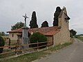
Saint-Jaymes Chapel

Memorial to the Fallen

The village school of Saint-Michel
_8.jpg)
_10.jpg)
.JPG)

_2.jpg)
.JPG)
traffic
The most important regional connection is the D979. Other important traffic routes are the D127, D211 and D237.
Web links
- Saint-Michel on the IGN side
- Village church and chapel
- Location of the place and brief information
- Sights of Saint-Michel on Le Patrimoine rural du Gers