
Lourties-Monbrun
|
Lourties-Monbrun Lortias e Montbrun |
||
|---|---|---|
|
||
| region | Occitania | |
| Department | Gers | |
| Arrondissement | Mirande | |
| Canton | Astarac gimone | |
| Community association | Val de Gers | |
| Coordinates | 43 ° 27 ' N , 0 ° 32' E | |
| height | 192-301 m | |
| surface | 9.50 km 2 | |
| Residents | 158 (January 1, 2017) | |
| Population density | 17 inhabitants / km 2 | |
| Post Code | 32140 | |
| INSEE code | 32216 | |
| Website | https://lourties-monbrun.a3w.fr/ | |
 Parish hall (Mairie) of Lourties-Monbrun |
||

Lourties-Monbrun ( Gascon : Lortias e Montbrun) is a French municipality with 158 inhabitants (at January 1, 2017) in the department of Gers in the region Occitania (2015 Midi-Pyrénées ); it belongs to the arrondissement of Mirande and the municipal association Val de Gers . The residents call themselves Lourtissois / Lourtissoises .
geography
Lourties-Monbrun is located around 13 kilometers south-east of Mirande and 22 kilometers south-south-west of Auch in the south of the Gers department. The community consists of the hamlet Lourties, numerous scattered settlements and individual farmsteads. The river Sousson crosses the parish in a northerly direction and in parts forms the western parish boundary.
Neighboring municipalities are Labarthe in the north and north-east, Masseube in the east and south-east, Esclassan-Labastide in the south, Saint-Arroman in the south-west and west and Clermont-Pouyguillès in the west and north-west.
Population development
| year | 1793 | 1806 | 1891 | 1962 | 1968 | 1975 | 1982 | 1990 | 1999 | 2006 | 2011 | 2016 |
| Residents | 221 | 266 | 233 | 91 | 61 | 50 | 93 | 102 | 108 | 124 | 138 | 152 |
| Sources: Cassini, Lourties-Monbrun Cassini, Monbrun and INSEE | ||||||||||||
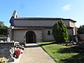
Saint-Jean-Baptiste village church

Memorial to the Fallen

Wayside cross at the cemetery


