
Manas-Bastanous
|
Manas-Bastanous Manàs e Bastanós |
||
|---|---|---|
|
||
| region | Occitania | |
| Department | Gers | |
| Arrondissement | Mirande | |
| Canton | Mirande-Astarac | |
| Community association | Astarac Arros en Gascogne | |
| Coordinates | 43 ° 22 ′ N , 0 ° 22 ′ E | |
| height | 204-318 m | |
| surface | 7.54 km 2 | |
| Residents | 81 (January 1, 2017) | |
| Population density | 11 inhabitants / km 2 | |
| Post Code | 32170 | |
| INSEE code | 32226 | |

Manas Bastanous ( Gascon : Manas e Bastanós) is a French municipality with 81 inhabitants (at January 1, 2017) in the department of Gers in the region Occitania (2015 Midi-Pyrénées ); it belongs to the Arrondissement Mirande and the municipality of Astarac Arros en Gascogne . The residents call themselves Manassois / Manassoises .
geography
Manas-Bastanous is located around 16 kilometers south-southwest of Mirande and 28 kilometers northeast of Tarbes in the south of the Gers department on the border with the Hautes-Pyrénées department . The community consists of hamlets, numerous scattered settlements and individual farmsteads.
Neighboring communities are Mont-de-Marrast in the north, Barcugnan in the east, Fontrailles (in the Hautes-Pyrénées department) in the south and Sarraguzan in the west.
history
In the Middle Ages, the three communities in Kastlanei Moncassin in the county of Astarac were located in the historic Gascon region and shared its fate. Arroux, Bastanous and Manas belonged to the Mirande district from 1793 to 1801. The municipalities have been assigned to the Arrondissement of Mirande since 1801 and belonged to the canton of Miélan from 1793 to 2015 . In 1822 the municipalities of Arroux (1821: 67 inhabitants), Bastanous (1821: 176 inhabitants) and Manas (1821: 142 inhabitants) united to form today's municipality.
Population development
The population development is typical for a French rural community. Developments between 1793 and 1831 are normal with growth. This was followed by a wave of emigration that continues to this day.
| year | 1793 | 1821 | 1831 | 1962 | 1968 | 1975 | 1982 | 1990 | 1999 | 2006 | 2011 | 2016 |
| Residents | 350 | 375 | 413 | 142 | 139 | 137 | 125 | 122 | 105 | 111 | 88 | 80 |
| today's municipal area Sources: Cassini, Arroux Cassini, Bastanous Cassini, Manas-Bastanous and INSEE | ||||||||||||
Attractions
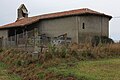
- Notre-Dame-de-l'Assomption village church in Manas
- Church Saint-Barthélémy in Bastanous
- Chapel of Aroux in Aroux (also known as the Église Notre-Dame-de-l'Assomption-de-la-Vierge )
- three wayside crosses
- Memorial to the Fallen

Town hall (Mairie) and school

Saint-Barthélémy village church in Bastanous
Chapel of Aroux

Memorial to the Fallen

.JPG)
_02.jpg)

traffic
The most important national connection is the D939. The most important regional transport connections for the municipality are the D145 and the D567.
Web links
- Manas-Bastanous on the IGN side
- Churches and chapel
- Location of the place and brief information
- Sights of Manas-Bastanous on Le Patrimoine rural du Gers