
Couloumé Mondebat
|
Couloumé-Mondebat Colomer e Mont Devath |
||
|---|---|---|
|
||
| region | Occitania | |
| Department | Gers | |
| Arrondissement | Mirande | |
| Canton | Pardiac-Rivière-Basse | |
| Community association | Bastides et Vallons du Gers | |
| Coordinates | 43 ° 39 ′ N , 0 ° 6 ′ E | |
| height | 122–245 m | |
| surface | 22.85 km 2 | |
| Residents | 194 (January 1, 2017) | |
| Population density | 8 inhabitants / km 2 | |
| Post Code | 32160 | |
| INSEE code | 32109 | |

Couloumé-Mondebat ( Gascon : Colomer e Mont Devath ) is a commune with 194 inhabitants (at January 1, 2017) in the department of Gers in the region Okzitanien ; it belongs to the Arrondissement Mirande and community association Communauté de communes Bastides et Vallons du Gers .
geography
Couloumé-Mondebat is around 40 kilometers (as the crow flies) west of the city. Also in the west of the Gers department. The place is part of the Côtes de Saint-Mont wine-growing region and the Armagnac brandy region . Numerous bodies of water originate or cross the municipal area. Most important are the Midou and Petit Midour rivers . There are also several small dams in the municipality. The community is close to the regional transport links D3 / D946 and D935. The closest bus stop is Castelnau-Rivière-Basse on line 940 Tarbes - Mont-de-Marsan.
The municipality consists of the villages of Couloumé (182 m above sea level) and Mondebat (200 m above sea level), the hamlet of Bières (186 m above sea level) and numerous farms.
Couloumé-Mondebat is surrounded by the neighboring communities of Aignan in the north. Castelnavet in the northeast, Saint-Pierre-d'Aubézies in the east, Peyrusse-Vieille in the southeast, Louslitges in the south, Beaumarchés in the southwest, Lasserrade in the west and Loussous-Débat in the northwest.
history
Historically, the municipality is located within Gascony and belongs to the Astarac region . From 1793 to 1801 Couloumé-Mondebat belonged to the Nogaro district. From 1793 to 1801 also to the canton of Beaumarchés, then to 2015 to the canton Plaisance .
Population development
| year | 1793 | 1800 | 1806 | 1821 | 1831 | 1851 | 1861 | 1886 | 1891 | 1962 | 1968 | 1975 | 1982 | 1990 | 1999 | 2006 | 2012 |
|---|---|---|---|---|---|---|---|---|---|---|---|---|---|---|---|---|---|
| Residents | 173 | 361 | 180 | 193 | 940 | 925 | 839 | 765 | 658 | 367 | 331 | 271 | 263 | 232 | 243 | 213 | 198 |
| Sources: Cassini and INSEE | |||||||||||||||||
Attractions
- Church Saint-Jean-Baptiste in Couloumé
- Church Saint-Barthélémy in Mondebat
- Chapel of Saint-Etienne in Bières
- Castle Château de Couloumé from the 18th century (now a holiday home)
- several calvaries, wayside crosses and statues of the Virgin Mary

Château de Couloumé castle

Saint-Jean-Baptiste village church in Couloumé

Mairie (Municipal House) by Couloumé-Mondebat

House in Couloumé
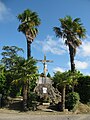
Memorial plaque for the fallen, with calvary
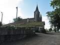
Saint-Barthélémy church in Mondebat

Landscape at Mondebat


