
Sainte-Foy-d'Aigrefeuille
| Sainte-Foy-d'Aigrefeuille | ||
|---|---|---|

|
|
|
| region | Occitania | |
| Department | Haute-Garonne | |
| Arrondissement | Toulouse | |
| Canton | Escalquens | |
| Community association | Terres du Lauragais | |
| Coordinates | 43 ° 33 ' N , 1 ° 37' E | |
| height | 152-240 m | |
| surface | 9.68 km 2 | |
| Residents | 2,011 (January 1, 2017) | |
| Population density | 208 inhabitants / km 2 | |
| Post Code | 31570 | |
| INSEE code | 31480 | |
| Website | www.mairiesaintefoydaigrefeuille.fr | |
 Town hall of Sainte-Foy-d'Aigrefeuille |
||

Sainte-Foy-d'Aigrefeuille is a commune with 2,011 inhabitants (as of January 1, 2017) in the French department of Haute-Garonne in the Occitanie region . The municipality belongs to the arrondissement of Toulouse and the canton of Escalquens (until 2015: canton of Lanta ). The inhabitants are called Saint-Foyens .
geography
Sainte-Foy-d'Aigrefeuille is about fourteen kilometers southeast of Toulouse in the Lauragais at the Saune . Sainte-Foy-d'Aigrefeuille is surrounded by the neighboring communities of Aigrefeuille in the north and north-west, Drémil-Lafage and Saint-Pierre-de-Lages in the north, Lanta in the east and north-east, Préserville in the south and south-east, Odars in the south, Auzielle in the West and south-west and Lauzerville to the west and north-west.
Population development
| 1962 | 1968 | 1975 | 1982 | 1990 | 1999 | 2006 | 2012 |
|---|---|---|---|---|---|---|---|
| 249 | 280 | 272 | 322 | 688 | 1,631 | 1,886 | 1.994 |
Attractions
- Sainte-Foy church
- Old castle
- Eugène-Maurice Fontanille Park

Sainte-Foy church

Eugène-Maurice Fontanille Park
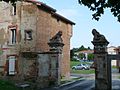
Entrance to the old castle


literature
- Le Patrimoine des Communes de la Haute-Garonne. Flohic Editions, Volume 1, Paris 2000, ISBN 2-84234-081-7 , pp. 836-837.