
Gibel
|
Gibel Gibèl |
||
|---|---|---|
|
||
| region | Occitania | |
| Department | Haute-Garonne | |
| Arrondissement | Toulouse | |
| Canton | Escalquens | |
| Community association | Terres du Lauragais | |
| Coordinates | 43 ° 18 ′ N , 1 ° 41 ′ E | |
| height | 215–343 m | |
| surface | 19.4 km 2 | |
| Residents | 361 (January 1, 2017) | |
| Population density | 19 inhabitants / km 2 | |
| Post Code | 31560 | |
| INSEE code | 31220 | |
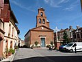
 Town Hall (Mairie) by Gibel |
||

Gibel ( Occitan : Gibel ) is in the southwest of France located community with 361 inhabitants (as of January 1 2017) in the department of Haute-Garonne in the region Occitania (before 2016: Midi-Pyrenees ). It belongs to the arrondissement of Toulouse and is part of the canton of Escalquens (until 2015: canton of Nailloux ). The inhabitants are called Gibelains .
geography
Gibel is located about 39 kilometers south-southeast of Toulouse in the Lauragais countryside . Gibel is surrounded by the neighboring communities of Monestrol in the north, Caignac in the northeast, Marquein in the east, Fajac-la-Relenque in the east and southeast, Molandier in the southeast, Mazères in the south, Calmont in the west and Montgeard in the northwest.
The A66 autoroute runs through the municipality .
Population development
| 1962 | 1968 | 1975 | 1982 | 1990 | 1999 | 2006 | 2017 | |
|---|---|---|---|---|---|---|---|---|
| 354 | 288 | 223 | 246 | 207 | 261 | 268 | 361 | |
| Sources: Cassini and INSEE | ||||||||
Attractions
- Saint-Antoine church
- House Coulom, 18th century mansion, historic monument since 1990
Saint-Antoine church

House Coulom


literature
- Le Patrimoine des Communes de la Haute-Garonne. Flohic Editions, Volume 2, Paris 2000, ISBN 2-84234-081-7 , pp. 1125-1126.