
Trébons-sur-la-Grasse
|
Trébons-sur-la-Grasse Trebons de la Grassa |
||
|---|---|---|
|
||
| region | Occitania | |
| Department | Haute-Garonne | |
| Arrondissement | Toulouse | |
| Canton | Revel | |
| Community association | Terres du Lauragais | |
| Coordinates | 43 ° 27 ' N , 1 ° 43' E | |
| height | 175-272 m | |
| surface | 10.87 km 2 | |
| Residents | 450 (January 1, 2017) | |
| Population density | 41 inhabitants / km 2 | |
| Post Code | 31290 | |
| INSEE code | 31560 | |
 Town hall (Mairie) of Trébons-sur-la-Grasse |
||

Trébons-sur-la-Grasse ( Occitan : Trebons de la Grassa ) is a French commune with 450 inhabitants (as of January 1, 2017) in the Haute-Garonne department in the Occitania region (before 2016 Midi-Pyrénées ). The municipality belongs to the arrondissement of Toulouse and the canton of Revel (until 2015 Villefranche-de-Lauragais ). The inhabitants are called Trébonais .
location
Trébons-sur-la-Grasse is located in the cultural landscape of the Lauragais . Trébons-sur-la-Grasse is surrounded by the neighboring communities of Saint-Germier in the north, Cessales in the northeast, Saint-Vincent in the east and southeast, Vallègue in the southeast, Montgaillard-Lauragais in the south and southwest, Mauremont in the west and Varennes in the northwest.
Population development
| year | 1962 | 1968 | 1975 | 1982 | 1990 | 1999 | 2006 | 2013 |
| Residents | 240 | 181 | 184 | 204 | 249 | 322 | 375 | 449 |
| Source: Cassini and INSEE | ||||||||
Attractions
- Saint-Martin church from the 13th century, monument historique since 1914
- old castle from the 13th century, alterations from the 17th century
- En Rigaud Castle from the 18th century
- Mill ruins from the 16th and 18th centuries
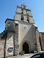
Saint Martin Church

Old castle


literature
- Le Patrimoine des Communes de la Haute-Garonne. Flohic Editions, Volume 2, Paris 2000, ISBN 2-84234-081-7 , pp. 1733-1736.