
Pelleport (Haute-Garonne)
|
Pelleport Pelapòrc |
||
|---|---|---|

|
|
|
| region | Occitania | |
| Department | Haute-Garonne | |
| Arrondissement | Toulouse | |
| Canton | Léguevin | |
| Community association | Save Garonne and Coteaux de Cadours | |
| Coordinates | 43 ° 44 ' N , 1 ° 7' E | |
| height | 157-275 m | |
| surface | 10.38 km 2 | |
| Residents | 515 (January 1, 2017) | |
| Population density | 50 inhabitants / km 2 | |
| Post Code | 31480 | |
| INSEE code | 31413 | |
| Website | http://www.mairie-pelleport31.fr/ | |
_La_Mairie.jpg) Town hall (Mairie) of Pelleport |
||

Pelleport ( Occitan : Pelapòrc ) is a French commune with 515 inhabitants (as of January 1, 2017) in the Haute-Garonne department in the Occitanie region . It belongs to the Arrondissement of Toulouse and the Canton of Léguevin (until 2015: Canton Cadours ). The inhabitants are called Pelleportains .
geography
Pelleport is located about 30 kilometers northwest of Toulouse in the south of France. Pelleport is surrounded by the neighboring communities of Drudas in the north and northwest, Launac in the east, Thil in the south and southeast, Le Grès in the south and southwest, Cadours in the west and southwest and Puysségur in the west.
Population development
| year | 1962 | 1968 | 1975 | 1982 | 1990 | 1999 | 2006 | 2013 |
| Residents | 190 | 176 | 163 | 221 | 310 | 344 | 459 | 545 |
| Source: Cassini and INSEE | ||||||||
Attractions
- Notre-Dame church
- Saint-Pé chapel
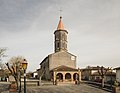
Notre-Dame church

Saint-Pé chapel
_Eglise.jpg)
_chapelle_Saint-P%C3%A9_1.jpg)
literature
- Le Patrimoine des Communes de la Haute-Garonne. Flohic Editions, Volume 1, Paris 2000, ISBN 2-84234-081-7 , pp. 429-430.
Web links
Commons : Pelleport - collection of images, videos and audio files