
Falga
|
Falga Le Falgar |
||
|---|---|---|
.svg)
|
|
|
| region | Occitania | |
| Department | Haute-Garonne | |
| Arrondissement | Toulouse | |
| Canton | Revel | |
| Community association | Lauragais Revel Sorèzois | |
| Coordinates | 43 ° 29 ′ N , 1 ° 52 ′ E | |
| height | 209-286 m | |
| surface | 5.38 km 2 | |
| Residents | 124 (January 1, 2017) | |
| Population density | 23 inhabitants / km 2 | |
| Post Code | 31540 | |
| INSEE code | 31180 | |
 Town Hall (Mairie) of Falga |
||

Falga ( Occitan Le Falgar ) is a French commune with 124 inhabitants (as of January 1, 2017) in the Haute-Garonne department in the Occitania region (before 2016 Midi-Pyrénées ). The municipality belongs to the arrondissement of Toulouse and the canton of Revel . The inhabitants are called Falgasiens .
location
Falga is located in the Lauragais countryside , about 36 kilometers east-southeast of Toulouse . Falga is surrounded by the neighboring communities Auriac-sur-Vendinelle in the north and north-west, Saint-Félix-Lauragais in the south and east, Vaux in the south-west and Maurens in the west and south-west.
Population development
| year | 1962 | 1968 | 1975 | 1982 | 1990 | 1999 | 2006 | 2017 |
| Residents | 110 | 67 | 57 | 60 | 73 | 79 | 98 | 124 |
| Sources: Cassini and INSEE | ||||||||
Attractions
- Saint Martin Church
- Castle from 1681
- old windmill
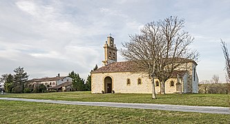
Saint Martin Church

lock


Personalities
- Siblings Caffarelli du Falga:
- Louis Marie Joseph Maximilien Caffarelli du Falga (1756–1799), Brigadier General
- Charles-Ambroise Caffarelli (1758–1826), Prefect
- Joseph Caffarelli (1760-1845), Vice Admiral
- Jean-Baptiste-Marie Caffarelli (1763–1815), Bishop of Saint-Brieuc
- Marie François Auguste de Caffarelli (1766–1849), division general
literature
- Le Patrimoine des Communes de la Haute-Garonne. Flohic Editions, Volume 2, Paris 2000, ISBN 2-84234-081-7 , pp. 1158-1161.
Web links
Commons : Falga - collection of images, videos and audio files