Castelmaurou
|
Castelmaurou Castèlmauron |
||
|---|---|---|

|
|
|
| region | Occitania | |
| Department | Haute-Garonne | |
| Arrondissement | Toulouse | |
| Canton | Pechbonnieu | |
| Community association | Coteaux Bellevue | |
| Coordinates | 43 ° 41 ′ N , 1 ° 32 ′ E | |
| height | 132-231 m | |
| surface | 16.77 km 2 | |
| Residents | 4,273 (January 1, 2017) | |
| Population density | 255 inhabitants / km 2 | |
| Post Code | 31180 | |
| INSEE code | 31117 | |
| Website | http://www.mairie-castelmaurou.fr/ | |
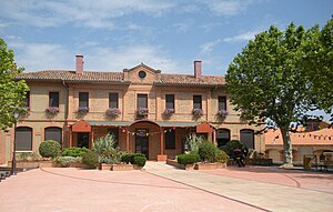
 Castelmaurou Town Hall |
||
Castelmaurou ( Occitan : Castèlmauron ) is a French commune with 4273 inhabitants (as of January 1, 2017) in the Haute-Garonne department in the Occitanie region ; it belongs to the Arrondissement of Toulouse and the Canton of Pechbonnieu . The inhabitants are called Castelmaurousien (ne) s .
geography
Castelmaurou is twelve kilometers as a banlieue northeast of Toulouse . The Girou flows on the northern municipal boundary . Castelmaurou is surrounded by the neighboring communities of Bazus in the north, Garidech in the northeast, Gragnague in the east, Beaupuy in the southeast, Rouffiac-Tolosan in the south, Saint-Jean in the southwest, Saint-Geniès-Bellevue in the west and Lapeyrouse-Fossat in the northwest.
The former Route nationale 88 (today's D888) and the Autoroute A68 with the motorway triangle to the Autoroute A680 lead through the municipality along the eastern municipal border.
Population development
| year | 1962 | 1968 | 1975 | 1982 | 1990 | 1999 | 2006 | 2017 |
| Residents | 809 | 918 | 1458 | 1611 | 2849 | 3261 | 3373 | 4273 |
Attractions
- Sainte-Foy church from 1832 with the relics of a martyr from 866.
literature
- Le Patrimoine des Communes de la Haute-Garonne. Flohic Editions, Volume 2, Paris 2000, ISBN 2-84234-081-7 , pp. 1498-1499.
