
Montrabé
|
Montrabé Monrabe |
||
|---|---|---|
.svg)
|
|
|
| region | Occitania | |
| Department | Haute-Garonne | |
| Arrondissement | Toulouse | |
| Canton | Toulouse-10 | |
| Community association | Toulouse metropolis | |
| Coordinates | 43 ° 39 ′ N , 1 ° 32 ′ E | |
| height | 143-211 m | |
| surface | 5.23 km 2 | |
| Residents | 4,106 (January 1, 2017) | |
| Population density | 785 inhabitants / km 2 | |
| Post Code | 31850 | |
| INSEE code | 31389 | |
| Website | http://www.mairie-montrabe.fr/ | |
 François-Mitterrand-Platz |
||

Montrabé ( Occitan : Monrabe ) is a southern French municipality with 4106 inhabitants (as of January 1, 2017) in the Haute-Garonne department in the Occitania region . It belongs to the Arrondissement of Toulouse and the Canton of Toulouse-10 . The inhabitants are called Montrabéen (ne) s .
geography
Montrabé is a banlieue in the northeast of Toulouse on the Sausse River . Montrabé is surrounded by the neighboring communities of Rouffiac-Tolosan in the north, Beaupuy in the north-east and east, Mondouzil in the south-east, Pin-Balma in the south and south-east, Balma in the south and south-west, L'Union in the west and north-west and Saint-Jean in the north-west.
The A68 autoroute runs along the northern border of the municipality .
Population development
| year | Residents |
|---|---|
| 1962 | 286 |
| 1968 | 353 |
| 1975 | 821 |
| 1982 | 1,740 |
| 1990 | 2,347 |
| 1999 | 3,201 |
| 2006 | 3,332 |
| 2011 | 3,700 |
Attractions
- Saint-Martial church
- Calvaire
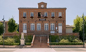
town hall

Saint-Martial church


Personalities
- Auguste Belloc (1800–1867), photographer
literature
- Le Patrimoine des Communes de la Haute-Garonne. Flohic Editions, Volume 2, Paris 2000, ISBN 2-84234-081-7 , pp. 1531-1534.