
Laréole
|
Laréole La Reula |
||
|---|---|---|
|
||
| region | Occitania | |
| Department | Haute-Garonne | |
| Arrondissement | Toulouse | |
| Canton | Léguevin | |
| Community association | Save Garonne and Coteaux de Cadours | |
| Coordinates | 43 ° 44 ' N , 1 ° 1' E | |
| height | 135-272 m | |
| surface | 8.88 km 2 | |
| Residents | 171 (January 1, 2017) | |
| Population density | 19 inhabitants / km 2 | |
| Post Code | 31480 | |
| INSEE code | 31275 | |
 Town hall (Mairie) of Laréole |
||

Laréole ( Occitan : La Reula ) is a French commune with 171 inhabitants (as of January 1, 2017) in the Haute-Garonne department in the Occitania region (before 2016 Midi-Pyrénées ). It belongs to the arrondissement of Toulouse and the canton of Léguevin ( Cadours until 2015 ). The inhabitants are called Réolains .
geography
Laréole is located about 37 kilometers northwest of Toulouse in southern France. Laréole is surrounded by the neighboring communities of Brignemont in the north, Cox in the north and northeast, Puysségur in the east, Cadours in the south and southeast, Ardizas in the west and southwest and Sainte-Anne in the northwest.
Population development
| year | 1962 | 1968 | 1975 | 1982 | 1990 | 1999 | 2006 | 2013 |
| Residents | 183 | 152 | 146 | 138 | 114 | 122 | 134 | 159 |
| Source: Cassini and INSEE | ||||||||
Attractions
See also: List of Monuments historiques in Laréole
- Notre-Dame church
- Laréole Castle from 1579 with a garden from the 18th century
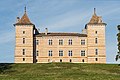
Laréole Castle

Notre-Dame church


Personalities
- Keith Campbell (1931-1958), motorcycle racer
literature
- Le Patrimoine des Communes de la Haute-Garonne. Flohic Editions, Volume 1, Paris 2000, ISBN 2-84234-081-7 , pp. 427-429.
Web links
Commons : Laréole - collection of images, videos and audio files