
Bélesta-en-Lauragais
|
Bélesta-en-Lauragais Belestar de Lauragués |
||
|---|---|---|
.svg)
|
|
|
| region | Occitania | |
| Department | Haute-Garonne | |
| Arrondissement | Toulouse | |
| Canton | Revel | |
| Community association | Lauragais Revel Sorèzois | |
| Coordinates | 43 ° 27 ' N , 1 ° 49' E | |
| height | 209-300 m | |
| surface | 5.59 km 2 | |
| Residents | 115 (January 1, 2017) | |
| Population density | 21 inhabitants / km 2 | |
| Post Code | 31540 | |
| INSEE code | 31060 | |
 Town hall (Mairie) of Bélesta-en-Lauragais |
||

Bélesta-en-Lauragais ( Occitan Belestar de Lauragués ) is a French commune with 115 inhabitants (as of January 1, 2017) in the Haute-Garonne department in the Occitania region (before 2016 Midi-Pyrénées ). The municipality belongs to the arrondissement of Toulouse and the canton of Revel . The inhabitants are called Bélestais .
location
Bélesta-en-Lauragais is located in the Lauragais countryside , about 35 kilometers southeast of Toulouse . Bélesta-en-Lauragais is surrounded by the neighboring communities of Vaux in the north, Saint-Félix-Lauragais in the east, Les Cassés in the east and south-east, Mouvilles-Hautes in the south and Juzes in the west.
Population development
| year | 1962 | 1968 | 1975 | 1982 | 1990 | 1999 | 2006 | 2017 |
| Residents | 109 | 74 | 61 | 72 | 66 | 84 | 107 | 115 |
| Sources: Cassini and INSEE | ||||||||
Attractions
- Saint-Jean-Baptiste church
- Tower of the former manor house

Saint-Jean-Baptiste church
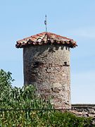
Tower of the former manor house


literature
- Le Patrimoine des Communes de la Haute-Garonne. Flohic Editions, Volume 2, Paris 2000, ISBN 2-84234-081-7 , pp. 1155-1157.
Web links
Commons : Bélesta-en-Lauragais - Collection of images, videos and audio files