
Monestrol
|
Monestrol Monestròl |
||
|---|---|---|
.svg)
|
|
|
| region | Occitania | |
| Department | Haute-Garonne | |
| Arrondissement | Toulouse | |
| Canton | Escalquens | |
| Community association | Terres du Lauragais | |
| Coordinates | 43 ° 20 ′ N , 1 ° 40 ′ E | |
| height | 209-302 m | |
| surface | 5.23 km 2 | |
| Residents | 62 (January 1, 2017) | |
| Population density | 12 inhabitants / km 2 | |
| Post Code | 31560 | |
| INSEE code | 31354 | |
 City Hall (Mairie) of Monestrol |
||

Monestrol ( Occitan : Monestròl ) is a French commune with 62 inhabitants (as of January 1, 2017) in the Haute-Garonne department in the Occitania region (before 2016 Midi-Pyrénées ). Cintegabelle belongs to the Arrondissement of Toulouse and the Canton of Escalquens (until 2015 Nailloux ). The inhabitants are called Monestrolois .
geography
Monestrol is located about 35 kilometers south of Toulouse in the Lauragais . Monestrol is surrounded by the neighboring communities of Montgeard in the north and west, Lagarde in the east, Caignac in the southeast and Gibel in the south.
Population development
| year | 1962 | 1968 | 1975 | 1982 | 1990 | 1999 | 2006 | 2017 |
| Residents | 83 | 76 | 72 | 80 | 60 | 55 | 56 | 62 |
| Sources: Cassini and INSEE | ||||||||
Attractions
- Saint-Pierre church
- Monestrol Castle
- Lasserre Castle

Saint-Pierre church
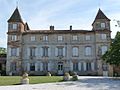
Monestrol Castle


literature
- Le Patrimoine des Communes de la Haute-Garonne. Flohic Editions, Volume 2, Paris 2000, ISBN 2-84234-081-7 , p. 1127.
Web links
Commons : Monestrol - collection of images, videos and audio files