
Renneville (Haute-Garonne)
|
Renneville Renevila |
||
|---|---|---|
.svg)
|
|
|
| region | Occitania | |
| Department | Haute-Garonne | |
| Arrondissement | Toulouse | |
| Canton | Revel | |
| Community association | Terres du Lauragais | |
| Coordinates | 43 ° 23 ' N , 1 ° 43' E | |
| height | 172-273 m | |
| surface | 8.42 km 2 | |
| Residents | 550 (January 1, 2017) | |
| Population density | 65 inhabitants / km 2 | |
| Post Code | 31290 | |
| INSEE code | 31450 | |
 Renneville Town Hall (Mairie) |
||

Renneville ( Occitan : Renevila ) is a French commune with 550 inhabitants (as of January 1, 2017) in the Haute-Garonne department in the Occitania region (before 2016 Midi-Pyrénées ). The municipality belongs to the arrondissement of Toulouse and the canton of Revel (until 2015 Villefranche-de-Lauragais ). The inhabitants are called Rennevillois .
location
Renneville is located in the cultural landscape of the Lauragais on the Canal du Midi . The Hers-Mort crosses the municipality. Renneville is surrounded by the neighboring communities of Villefranche-de-Lauragais in the north, Avignonet-Lauragais in the east and southeast, Montclar-Lauragais in the south and Gardouch in the west.
The A61 autoroute runs through the municipality .
Population development
| year | 1962 | 1968 | 1975 | 1982 | 1990 | 1999 | 2006 | 2013 |
| Residents | 204 | 215 | 222 | 262 | 334 | 334 | 448 | 518 |
| Source: Cassini and INSEE | ||||||||
Attractions
- Saint-Jacques church
- Les Voûtes aqueduct, built in 1688, monument historique since 1998
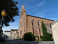
Saint-Jacques church

Les Voûtes aqueduct


literature
- Le Patrimoine des Communes de la Haute-Garonne. Flohic Editions, Volume 2, Paris 2000, ISBN 2-84234-081-7 , pp. 1725-1727.