
Francarville
|
Francarville Francarvila |
||
|---|---|---|
|
||
| region | Occitania | |
| Department | Haute-Garonne | |
| Arrondissement | Toulouse | |
| Canton | Revel | |
| Community association | Terres du Lauragais | |
| Coordinates | 43 ° 35 ' N , 1 ° 45' E | |
| height | 161-256 m | |
| surface | 7 km 2 | |
| Residents | 174 (January 1, 2017) | |
| Population density | 25 inhabitants / km 2 | |
| Post Code | 31460 | |
| INSEE code | 31194 | |
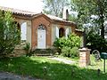
 City Hall (Mairie) of Francarville |
||

Francarville ( Occitan Francarvila ) is a French commune with 174 inhabitants (as of January 1, 2017) in the Haute-Garonne department in the Occitanie region (before 2016 Midi-Pyrénées ). The municipality belongs to the arrondissement of Toulouse and the canton of Revel ( Caraman until 2015 ). The inhabitants are called Francarvillois .
location
Francarville is located in the cultural landscape of the Lauragais . The Girou crosses the municipality in the northeast. Francarville is surrounded by the neighboring communities of Bannières in the north and northeast, Vendine in the east, Loubens-Lauragais in the southeast, Mascarville in the south, Prunet in the southwest and Saussens in the west and northwest.
Population development
| year | 1962 | 1968 | 1975 | 1982 | 1990 | 1999 | 2006 | 2013 |
| Residents | 125 | 100 | 67 | 103 | 108 | 154 | 169 | 184 |
| Source: Cassini and INSEE | ||||||||
Attractions
- Notre-Dame church
- old rectory

Notre-Dame church
Old rectory


literature
- Le Patrimoine des Communes de la Haute-Garonne. Flohic Editions, Volume 1, Paris 2000, ISBN 2-84234-081-7 , pp. 464-466.
Web links
Commons : Francarville - Collection of Images, Videos, and Audio Files