Montesquieu-Lauragais
|
Montesquieu-Lauragais Montesquiu de Lauragués |
||
|---|---|---|

|
|
|
| region | Occitania | |
| Department | Haute-Garonne | |
| Arrondissement | Toulouse | |
| Canton | Revel | |
| Community association | Terres du Lauragais | |
| Coordinates | 43 ° 25 ' N , 1 ° 38' E | |
| height | 158-274 m | |
| surface | 24.75 km 2 | |
| Residents | 977 (January 1, 2017) | |
| Population density | 39 inhabitants / km 2 | |
| Post Code | 31450 | |
| INSEE code | 31374 | |
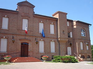
 Town hall (Mairie) of Montesquieu-Lauragais |
||
Montesquieu-Lauragais ( Occitan : Montesquiu de Lauragués ) is a French commune with 977 inhabitants (as of January 1, 2017) in the Haute-Garonne department in the Occitanie region . The municipality belongs to the arrondissement of Toulouse and the canton of Revel (until 2015: canton of Villefranche-de-Lauragais ). The inhabitants are called Montesquiriens .
location
Montesquieu-Lauragais is located in the cultural landscape of the Lauragais on the Canal du Midi . The Hers-Mort limits the community in the northeast. Montesquieu-Lauragais is surrounded by the neighboring communities of Baziège in the north and north-west, Villenouvelle in the north and north-east, Saint-Rome , Vieillevigne and Gardouch in the east, Seyre in the south-east, Nailloux in the south and Ayguesvives in the west and north-west.
The A61 Autoroute and the A66 Autoroute run through the municipality.
Population development
| year | 1962 | 1968 | 1975 | 1982 | 1990 | 1999 | 2006 | 2013 |
| Residents | 612 | 646 | 564 | 654 | 742 | 846 | 892 | 925 |
| Source: Cassini and INSEE | ||||||||
Attractions
See also: List of Monuments historiques in Montesquieu-Lauragais
- Saint-Jacques church
- Négra lock and bridge on the Canal du Midi
literature
- Le Patrimoine des Communes de la Haute-Garonne. Flohic Editions, Volume 2, Paris 2000, ISBN 2-84234-081-7 , pp. 1719-1722.
