
Léguevin
|
Léguevin Legavin |
||
|---|---|---|
.svg)
|
|
|
| region | Occitania | |
| Department | Haute-Garonne | |
| Arrondissement | Toulouse | |
| Canton | Léguevin (main town) | |
| Community association | Save au touch | |
| Coordinates | 43 ° 36 ' N , 1 ° 14' E | |
| height | 164-237 m | |
| surface | 24.45 km 2 | |
| Residents | 9,196 (January 1, 2017) | |
| Population density | 376 inhabitants / km 2 | |
| Post Code | 31490 | |
| INSEE code | 31291 | |
| Website | http://www.ville-leguevin.fr/ | |
 Town hall ( mairie ) of Léguevin |
||

Léguevin ( Occitan : Legavin ) is a municipality with 9,196 inhabitants (as of January 1, 2017) in the Haute-Garonne department in the Occitania region in southwest France . Léguevin belongs to the arrondissement of Toulouse and is the main town ( chef-lieu ) of the canton of Léguevin . The inhabitants are called Léguevinois .
geography
The Aussonnelle runs through the community . Her tributary Courbet also swells here . Léguevin is surrounded by the neighboring communities of Brax in the north, Pibrac in the northeast, Plaisance-du-Touch in the east, La Salvetat-Saint-Gilles in the southeast, Fontenilles in the south and southwest, Pujaudran (Département Gers) in the west and Lasserre-Pradère and Mérenvielle in the north-west.
Route Nationale 124 and the southernmost Way of St. James, Via Tolosana, run through the municipality .
history
Léguevin is a bastide , even if the Johanniter owned land here as early as the 12th century.
Population development
- 1962: 1014
- 1968: 1622
- 1975: 2091
- 1982: 2764
- 1990: 4217
- 1999: 6172
- 2006: 7483
- 2011: 8566
- 2017: 9166
Attractions
- Saint-Jean-Baptiste church
- Château de Castelnouvel
- historical exchange station
- town hall
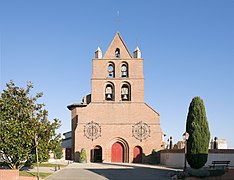
Saint-Jean-Baptiste church in Léguevin

Interior view of Saint-Jean-Baptiste

Ceiling over the altar

Château de Castelnouvel

old market hall

Historic exchange station


literature
- Le Patrimoine des Communes de la Haute-Garonne. Flohic Editions, Volume 1, Paris 2000, ISBN 2-84234-081-7 , pp. 844-846.