
Lanta
|
Lanta Lantar |
||
|---|---|---|
.svg)
|
|
|
| region | Occitania | |
| Department | Haute-Garonne | |
| Arrondissement | Toulouse | |
| Canton | Revel | |
| Community association | Terres du Lauragais | |
| Coordinates | 43 ° 34 ′ N , 1 ° 39 ′ E | |
| height | 159-275 m | |
| surface | 30.12 km 2 | |
| Residents | 2,070 (January 1, 2017) | |
| Population density | 69 inhabitants / km 2 | |
| Post Code | 31570 | |
| INSEE code | 31271 | |
| Website | http://www.lanta.fr/ | |
 Lanta Town Hall |
||

Lanta ( Occitan : Lantar ) is a municipality with 2,070 inhabitants (as of January 1, 2017) in the French department of Haute-Garonne in the Occitania region . The municipality belongs to the Arrondissement of Toulouse and the Canton of Revel (until 2015: Canton Lanta ). The inhabitants are called Lantanais .
geography
Lanta is located about 19 kilometers east of Toulouse in the Lauragais an der Saune . Lanta is surrounded by the neighboring communities Vallesvilles in the north, Bourg-Saint-Bernard in the north and northeast, Saussens in the northeast, Prunet in the east and northeast, Aurin in the south and southeast, Préserville in the south and southwest, Sainte-Foy-d'Aigrefeuille in the West and south-west and Saint-Pierre-de-Lages to the west.
history
During the 12./13. Century Lanta was a stronghold of the Catharism and from the 16th century of Protestantism .
Population development
| 1962 | 1968 | 1975 | 1982 | 1990 | 1999 | 2006 | 2017 |
|---|---|---|---|---|---|---|---|
| 913 | 874 | 908 | 1026 | 1144 | 1.75 | 1416 | 2070 |
| Sources: Cassini and INSEE | |||||||
Attractions
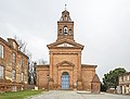
- Notre-Dame-de-l'Assomption church
- Sainte-Apollonie Church
- Saint-Anatoly Church
- Saint-Sernin church
- Old rectory
- town hall
- Pigeon tower
Notre-Dame-de-l'Assomption church

Saint-Anatoly Church

Old rectory

Saint Anatoly de Lanta

Pigeon tower at Saint-Anatoly


literature
- Le Patrimoine des Communes de la Haute-Garonne. Flohic Editions, Volume 1, Paris 2000, ISBN 2-84234-081-7 , pp. 828-831.