
Mondonville (Haute-Garonne)
|
Mondonville Mondonvila |
||
|---|---|---|

|
|
|
| region | Occitania | |
| Department | Haute-Garonne | |
| Arrondissement | Toulouse | |
| Canton | Blagnac | |
| Community association | Toulouse metropolis | |
| Coordinates | 43 ° 40 ′ N , 1 ° 17 ′ E | |
| height | 145-193 m | |
| surface | 11.89 km 2 | |
| Residents | 4,546 (January 1, 2017) | |
| Population density | 382 inhabitants / km 2 | |
| Post Code | 31700 | |
| INSEE code | 31351 | |
| Website | http://www.cornebarrieu.com/ | |
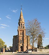
 Mondonville clock tower |
||

Mondonville ( Occitan Mondonvila ) is a commune in the Haute-Garonne department in the Occitanie region of France . It belongs to the arrondissement of Toulouse and the canton of Blagnac . The 4546 inhabitants (as of January 1, 2017) are called Mondonvillois (es) .
geography
Mondonville is a banlieue in the northwest of Toulouse . The small river Gajea , which feeds Lac d'Aussonne just beyond the northeastern municipal boundary, flows through Mondonville. A not inconsiderable part of the 2,700 hectare forest of Bouconne protrudes into the municipality. Mondonville is surrounded by the neighboring communities of Daux in the north and north-west, Aussonne in the north-east, Cornebarrieu in the east and south-east, Pibrac in the south, Lévignac in the south-west and Montaigut-sur-Save in the west.
Route Nationale 224 runs through the municipality as part of the Itinéraire à Grand Gabarit .
Population development
| year | 1962 | 1968 | 1975 | 1982 | 1990 | 1999 | 2006 | 2011 |
| Residents | 525 | 643 | 1,029 | 1,245 | 1,366 | 1,900 | 2,689 | 4,357 |
Attractions
- Saint-Pierre-ès-Liens church
- Bourg Castle

town hall

church


literature
- Le Patrimoine des Communes de la Haute-Garonne. Flohic Editions, Volume 1, Paris 2000, ISBN 2-84234-081-7 , pp. 364-369.