
Montbrun-Lauragais
| Montbrun-Lauragais | ||
|---|---|---|
.svg)
|
|
|
| region | Occitania | |
| Department | Haute-Garonne | |
| Arrondissement | Toulouse | |
| Canton | Escalquens | |
| Community association | Sicoval | |
| Coordinates | 43 ° 27 ' N , 1 ° 31' E | |
| height | 175-284 m | |
| surface | 10.92 km 2 | |
| Residents | 611 (January 1, 2017) | |
| Population density | 56 inhabitants / km 2 | |
| Post Code | 31450 | |
| INSEE code | 31366 | |
| Website | http://www.montbrun-lauragais.fr/ | |
 Town hall (Mairie) of Montbrun-Lauragais |
||

Montbrun-Lauragais Occitan Montbrun de Lauragués is a French commune with 611 inhabitants (as of January 1, 2017) in the Haute-Garonne department in the Occitania region . It belongs to the arrondissement of Toulouse and the canton of Escalquens (until 2015: canton of Montgiscard ). The inhabitants are called Montbrunois or Brunimontains .
geography
Montbrun-Lauragais is located about 17 kilometers south-southeast of Toulouse in the Lauragais landscape . Montbrun-Lauragais is surrounded by the neighboring communities of Deyme in the north, Donneville in the north-east, Montgiscard in the east, Pouze in the south and south-east, Issus in the south, Espanès in the west and south-west and Corronsac in the west and north-west.
Population development
| year | 1962 | 1968 | 1975 | 1982 | 1990 | 1999 | 2006 | 2017 |
| Residents | 201 | 190 | 201 | 253 | 360 | 485 | 541 | 611 |
| Sources: Cassini and INSEE | ||||||||
Attractions
See also: List of Monuments historiques in Montbrun-Lauragais
- Saint-Michel church
- Montbrun Castle
- Windmill from 1680, Monument historique

Saint-Michel church
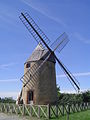
Windmill


literature
- Le Patrimoine des Communes de la Haute-Garonne. Flohic Editions, Volume 2, Paris 2000, ISBN 2-84234-081-7 , pp. 1010-1013.