
Montlaur (Haute-Garonne)
| Montlaur | ||
|---|---|---|
.svg)
|
|
|
| region | Occitania | |
| Department | Haute-Garonne | |
| Arrondissement | Toulouse | |
| Canton | Escalquens | |
| Community association | Sicoval | |
| Coordinates | 43 ° 29 ′ N , 1 ° 34 ′ E | |
| height | 149-227 m | |
| surface | 9.61 km 2 | |
| Residents | 1,576 (January 1, 2017) | |
| Population density | 164 inhabitants / km 2 | |
| Post Code | 31450 | |
| INSEE code | 31384 | |
 Town hall (Mairie) of Montlaur |
||

Montlaur is a French commune with 1,576 inhabitants (as of January 1, 2017) in the Haute-Garonne department in the Occitanie region (before 2016 Midi-Pyrénées ). It belongs to the arrondissement of Toulouse and the canton of Escalquens (until 2015: canton of Montgiscard ). The inhabitants are called Montlaurains .
geography
Montlaur is located about 14 kilometers southeast of Toulouse in the Lauragais countryside . Montlaur is surrounded by the neighboring communities of Belberaud in the north, Fourquevaux in the northeast, Baziège in the east and southeast, Montgiscard in the south, Donneville in the southwest and Deyme in the west.
Population development
| year | 1962 | 1968 | 1975 | 1982 | 1990 | 1999 | 2006 | 2013 |
| Residents | 363 | 403 | 527 | 646 | 807 | 889 | 1,172 | 1,187 |
| Source: Cassini and INSEE | ||||||||
Attractions
See also: List of Monuments historiques in Montlaur (Haute-Garonne)
- Saint-Lautier church
- Montlaur Castle, classified as a Monument historique since 1982

Saint-Lautier church
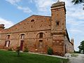
Montlaur Castle


literature
- Le Patrimoine des Communes de la Haute-Garonne. Flohic Editions, Volume 2, Paris 2000, ISBN 2-84234-081-7 , pp. 1020-1022.
Web links
Commons : Montlaur - collection of images, videos and audio files