
Aurin (Haute-Garonne)
|
Aurin Aurinh |
||
|---|---|---|
|
||
| region | Occitania | |
| Department | Haute-Garonne | |
| Arrondissement | Toulouse | |
| Canton | Revel | |
| Community association | Terres du Lauragais | |
| Coordinates | 43 ° 32 ' N , 1 ° 41' E | |
| height | 167-265 m | |
| surface | 7.49 km 2 | |
| Residents | 332 (January 1, 2017) | |
| Population density | 44 inhabitants / km 2 | |
| Post Code | 31570 | |
| INSEE code | 31029 | |
 Mairie Aurin |
||

Aurin , in Occitan Aurinh , is a French commune with 332 inhabitants (as of January 1, 2017) in the Haute-Garonne department in the Occitania region (previously Midi-Pyrénées ).
geography
Aurin is located in the Lauragais an der Saune at an average altitude of 216 meters above sea level in the Castagniccia , 21 kilometers southeast of Toulouse , the capital of the Midi-Pyrénées region. The village is surrounded by the neighboring communities of Maureville , Lanta and Tarabel . The municipality has an area of 7.49 square kilometers.
Attractions
The Ste-Apollonie church is typical of the Lauragais. The bells of the relatively small building are fixed in a wall that is far higher than the rest of the building. The church was built in the 16th century and restored in the 19th century. In 1950 and 1996 the walls of the nave and porch were painted with scenes from the legend of the saints of Apollonia of Alexandria and from the life of Jesus against the background of landscapes from the Lauragais.
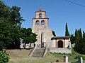
Sainte-Apollonie Church

Saint-André church


literature
- Le Patrimoine des Communes de la Haute-Garonne. Flohic Editions, Volume 1, Paris 2000, ISBN 2-84234-081-7 , pp. 824-825.
Web links
Individual evidence
- ↑ P. Pojada: Toponimia occitana e senhalizacion en occitan. In: toponimiaoc.webs.com. 2009, accessed September 8, 2011 (Occitan).
- ↑ Le village d'Aurin. In: Annuaire-Mairie.fr. Retrieved September 8, 2011 (French).