
Brignemont
|
Brignemont Brinhemont |
||
|---|---|---|
.svg)
|
|
|
| region | Occitania | |
| Department | Haute-Garonne | |
| Arrondissement | Toulouse | |
| Canton | Léguevin | |
| Community association | Save Garonne and Coteaux de Cadours | |
| Coordinates | 43 ° 47 ' N , 0 ° 59' E | |
| height | 136-286 m | |
| surface | 21.96 km 2 | |
| Residents | 387 (January 1, 2017) | |
| Population density | 18 inhabitants / km 2 | |
| Post Code | 31480 | |
| INSEE code | 31090 | |
 View of Brignemont |
||

Brignemont ( Occitan : Brinhemont ) is a municipality with 387 inhabitants (as of January 1, 2017) in southern France , in the Occitanie region and in the Haute-Garonne department . The municipality is located in the arrondissement of Toulouse and in the canton of Léguevin (until 2015: canton of Cadours ). The inhabitants are called Brignemontains .
geography
Brignemont is about 41 kilometers northwest of Toulouse . Brignemont is surrounded by the neighboring communities of Le Causé in the north, Cabanac-Séguenville in the north and northeast, Lagraulet-Saint-Nicolas in the east, Cox in the east and southeast, Laréole in the south, Encausse in the south, Sainte-Anne in the southwest, Sarrant in the west as well as Maubec in the northwest.
Population development
| 1962 | 1968 | 1975 | 1982 | 1990 | 1999 | 2006 | 2013 |
|---|---|---|---|---|---|---|---|
| 390 | 324 | 330 | 338 | 314 | 317 | 342 | 391 |
| Source: Cassini and INSEE | |||||||
Attractions
- Remnants of a Celtic oppidum
- Saint-Michel church
- Church of Sainte-Menne
- 18th century mill ( Monument historique )
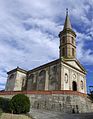
Saint-Michel church

Mill


literature
- Le Patrimoine des Communes de la Haute-Garonne. Flohic Editions, Volume 1, Paris 2000, ISBN 2-84234-081-7 , pp. 403-406.