Balma
|
Balma Balmar |
||
|---|---|---|

|
|
|
| region | Occitania | |
| Department | Haute-Garonne | |
| Arrondissement | Toulouse | |
| Canton | Toulouse-10 | |
| Community association | Toulouse metropolis | |
| Coordinates | 43 ° 37 ′ N , 1 ° 30 ′ E | |
| height | 135-218 m | |
| surface | 16.59 km 2 | |
| Residents | 16,568 (January 1, 2017) | |
| Population density | 999 inhabitants / km 2 | |
| Post Code | 31130 | |
| INSEE code | 31044 | |
| Website | http://www.mairie-balma.fr/ | |
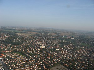
 View of Balma |
||
Balma ( Occitan : Balmar ) is a municipality in the south of France . Balma is located in the Occitanie region (previously Midi-Pyrénées ) in the Haute-Garonne department and is part of the Toulouse arrondissement and the canton of Toulouse-10 (previously Toulouse-8 ). The inhabitants are called Balmanais or Balmanaises .
geography
Balma is a banlieue of Toulouse on the eastern bank of the Hers-Mort . Balma is surrounded by the neighboring communities of L'Union in the north, Montrabé in the northeast, Pin-Balma in the east, Flourens in the southeast, Quint-Fonsegrives in the south and Toulouse in the west.
Development of the population
| year | Residents |
|---|---|
| 1962 | 2,890 |
| 1968 | 4,276 |
| 1975 | 7.127 |
| 1982 | 8,117 |
| 1990 | 9,506 |
| 1999 | 11,944 |
| 2006 | 12,793 |
| 2017 | 16,568 |
Attractions
- Château de Thégra
- Saint Joseph Church
- Saint-Martin-de-Boville church
See also: List of Monuments historiques in Balma
Personalities
- Gabriel de Gramont (1486–1534), Cardinal and Archbishop of Toulouse, died in the Archbishop's Château in Balma
- Léopold Niel (1846–1918), Brigadier General
- José Cabanis (1922–2000), lawyer and writer
literature
- Le Patrimoine des Communes de la Haute-Garonne. Flohic Editions, Volume 2, Paris 2000, ISBN 2-84234-081-7 , pp. 1489-1493.
Web links
Commons : Balma - collection of images, videos and audio files


