
Bazus
|
Bazus Basús |
||
|---|---|---|
.svg)
|
|
|
| region | Occitania | |
| Department | Haute-Garonne | |
| Arrondissement | Toulouse | |
| Canton | Pechbonnieu | |
| Community association | Coteaux du Girou | |
| Coordinates | 43 ° 44 ′ N , 1 ° 31 ′ E | |
| height | 128-216 m | |
| surface | 9.13 km 2 | |
| Residents | 553 (January 1, 2017) | |
| Population density | 61 inhabitants / km 2 | |
| Post Code | 31380 | |
| INSEE code | 31049 | |
 Town center |
||

Bazus ( Occitan : Basús ) is a French commune with 553 inhabitants (as of January 1, 2017) in the Haute-Garonne department in the Occitania region (before 2016: Midi-Pyrénées ). Bazus belongs to the arrondissement of Toulouse and until 2015 to the canton of Montastruc-la-Conseillère , since then to the canton of Pechbonnieu . The inhabitants are called Bazusien (ne) s .
geography
Bazus is located about 15 kilometers north-northeast of Toulouse . The Girou limits the municipality in the southwest. Bazus is surrounded by the neighboring communities of Montjoire in the north, Paulhac in the east and northeast, Garidech in the southeast, Castelmaurou and Lapeyrouse-Fossat in the south, Montberon in the southwest and Villariès in the west and northwest.
history
The place was under until the Revolution the landlords in Montastruc-la-Conseillère .
In 1790 the municipality of Bazus was formed.
Population development
| 1962 | 1968 | 1975 | 1982 | 1990 | 1999 | 2006 | 2013 |
|---|---|---|---|---|---|---|---|
| 262 | 252 | 289 | 372 | 437 | 532 | 575 | 575 |
| Source: Cassini and INSEE | |||||||
Attractions
- Church Saint-Pierre in the 15th century, rebuilding from the 18th century monument historique since 1978

town hall

Saint-Pierre church
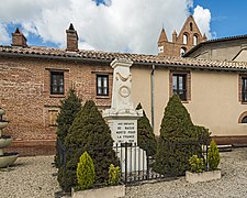
War memorial

Wash house


literature
- Le Patrimoine des Communes de la Haute-Garonne. Flohic Editions, Volume 2, Paris 2000, ISBN 2-84234-081-7 , p. 913.