
Clarens (Hautes-Pyrénées)
|
Clarens Clarenç |
||
|---|---|---|
.svg)
|
|
|
| region | Occitania | |
| Department | Hautes-Pyrénées | |
| Arrondissement | Bagneres-de-Bigorre | |
| Canton | La Vallée de la Barousse | |
| Community association | Plateau de Lannemezan | |
| Coordinates | 43 ° 10 ′ N , 0 ° 25 ′ E | |
| height | 406-602 m | |
| surface | 11.30 km 2 | |
| Residents | 507 (January 1, 2017) | |
| Population density | 45 inhabitants / km 2 | |
| Post Code | 65300 | |
| INSEE code | 65150 | |
.JPG) Clarens village church |
||

Clarens ( Occitan : Clarenç ) is a French commune with 507 inhabitants (as of January 1, 2017) in the Hautes-Pyrénées department in the Occitania region ; it belongs to the Arrondissement of Bagnères-de-Bigorre and the community association Plateau de Lannemezan . The inhabitants are called Clarensois / Clarensoises .
geography
Clarens is located around 28 kilometers east-southeast of the city of Tarbes in the east of the Hautes-Pyrénées department. The community consists of the village of Clarens and numerous scattered settlements. Clarens lies on the Lannemezan plateau . The Galavette (also Ruisseau de la Galavette) crosses the municipality in a northerly direction. The Baïse forms in parts a natural western municipal boundary. In terms of traffic, the community is on the D10. The A64 passes a few kilometers south of the community.
Clarens is surrounded by the neighboring communities of Galez in the north, Tajan in the northeast, Recurt and Uglas in the east, Lannemezan in the south and west and Campistrous in the west.
history
The parish is mentioned for the first time (indirectly) as de Clarens in the parish registers of Tarbes from 1342 . In the Middle Ages, the place was within the Rivière-Verdun region, which in turn was part of the Gascogne province. The municipality belonged to the District of Bagnères from 1793 to 1801. In addition, Clarens was from 1793 to 2015 within the canton of Lannemezan . The municipality has been part of the Bagnères-de-Bigorre arrondissement since 1801.
Population development
| year | 1793 | 1806 | 1846 | 1911 | 1921 | 1931 | 1954 | 1962 | 1968 | 1975 | 1982 | 1990 | 1999 | 2006 | 2014 |
| Residents | 340 | 328 | 490 | 418 | 368 | 274 | 273 | 299 | 330 | 330 | 346 | 375 | 394 | 436 | 504 |
| Sources: Cassini and INSEE | |||||||||||||||
Attractions
- Church Saint-André
- Memorial to the Fallen
- several wayside crosses (including Les Trois Croix at the village cemetery)
- La Tourbière nature reserve
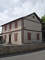
Mairie (Town Hall) by Clarens
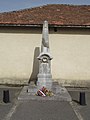
Memorial to the Fallen
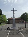
Cross in the village square

former draw well
.JPG)
.JPG)
.JPG)
.JPG)
Web links
- Statistics on cassini.ehess.fr
- Location of the place in France
- Clarens on the IGN's side
- Saint-André village church