Karbach (Hunsrück)
| coat of arms | Germany map | |
|---|---|---|

|
Coordinates: 50 ° 10 ′ N , 7 ° 37 ′ E |
|
| Basic data | ||
| State : | Rhineland-Palatinate | |
| County : | Rhein-Hunsrück district | |
| Association municipality : | Hunsrück-Middle Rhine | |
| Height : | 468 m above sea level NHN | |
| Area : | 4.98 km 2 | |
| Residents: | 628 (Dec. 31, 2019) | |
| Population density : | 126 inhabitants per km 2 | |
| Postal code : | 56281 | |
| Area code : | 06747 | |
| License plate : | SIM, GOA | |
| Community key : | 07 1 40 063 | |
| Association administration address: | Rathausstrasse 1 56281 Emmelshausen |
|
| Website : | ||
| Local Mayor : | Michael Bender | |
| Location of the local community Karbach in the Rhein-Hunsrück district | ||
Karbach is a municipality in the Rhein-Hunsrück district in Rhineland-Palatinate . It belongs to the Hunsrück-Mittelrhein community .
Geographical location
Karbach is about four kilometers east of Emmelshausen and seven kilometers west of the Rhine town of St. Goar . It is connected to the national transport network via the A 61 / Emmelshausen exit and the B 327 ( Hunsrückhöhenstrasse ).
history
The first mention of local settlement goes back to the located in the district court Quintenach, the 1109 (1110 confirmed) together with the farm Hirzenach in a document Pope Paschal II. The Abbey Siegburg was given with the proviso at the place a monastery following Hirzenach Provostry to build. Before 1256, the rights to the bailiwick passed through Hirzenach, Karbach and Quintenach to the Count Palatine near the Rhine . The lords of Ehrenburg, in turn, were enfeoffed with the district that they or their legal successors used, from 1666 the barons of Clodt. With the occupation of the left bank of the Rhine in 1794 by French revolutionary troops , the place became French, in 1815 it was assigned to the Kingdom of Prussia at the Congress of Vienna . Since 1946 the place has been part of the state of Rhineland-Palatinate.
- Population development
The development of the population of Karbach, the values from 1871 to 1987 are based on censuses:
|
|
politics
Municipal council
The municipal council in Karbach consists of twelve council members, who were elected by a majority vote in the local elections on May 26, 2019 , and the honorary local mayor as chairman.
mayor
Local mayor is Michael Bender. In the local elections on May 26, 2019, he was confirmed in his office with 79.20% of the votes.
coat of arms
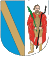
| Blazon : "The coat of arms shows a split shield: in front in blue a golden oblique left bar, behind in silver St. Quintin in golden mail shirt and red coat, in the right a green palm frond, in the left holding a roasting spit." | |
| Justification of the coat of arms: Karbach used to belong to the Ehrenburg lordship , hence the Ehrenburg coat of arms in front; St. Quintin is the patron saint of local patrons and is shown in the local St. Quintin's chapel with a skewer and palm fronds. |
Worth seeing
- The former parish church of St. Quintin , a pilgrimage destination since the 12th century, goes back to the 10th century due to its original building like the village of Karbach and the Hof Quintenach. In the Thirty Years' War destroyed, it was rebuilt in 1749 and sanctified 1,751th The single-nave church with a choir closed on three sides houses a wooden altar from 1275 with the depiction of Our Lady of Sorrows ( Pietà ), probably from the Minorite Monastery in Oberwesel , and a wooden statue of St. Quintin from the 14th century. Choir windows from 1899, 1909 and 1960, the year of the last major renovation, with pictures of the eponymous saint and depictions of the apparitions of the Virgin Mary give the church interior light.
- The small church of St. Anna was built around 1700 and expanded in 1923.
See also: List of cultural monuments in Karbach
Economy and public institutions
In the past 25 years or so, the area designated as agricultural land has decreased from approx. 50 percent to 42 percent of the municipal area, while the proportion of forest has increased from 40 percent to over 46 percent. The number of farms decreased as the farm size increased from 20 to 5. Few retail and service companies offer the most essential services on site, others in nearby Emmelshausen.
The Catholic community maintains a local kindergarten.
societies
- Culture and Carnival Association e. V.
- Mandolin and Wind Orchestra Rheinhöhe 1932 Karbach e. V.
- Football club "Blau-Weiß" Karbach e. V.
- Youth Club Karbach (JCK)
- Bachelor club Karbach e. V.
Web links
- Internet presence of the local community Karbach
- Literature about Karbach in the Rhineland-Palatinate State Bibliography
Individual evidence
- ↑ a b State Statistical Office of Rhineland-Palatinate - population status 2019, districts, municipalities, association communities ( help on this ).
- ^ Website about the former Hirzenach Provostry
- ↑ State Statistical Office Rhineland-Palatinate - regional data
- ^ The Regional Returning Officer RLP: Municipal Council Election 2019 Karbach. Retrieved October 5, 2019 .
- ↑ The regional returning officer RLP: direct elections 2019. see Hunsrück-Mittelrhein, Verbandsgemeinde, twelfth line of results. Retrieved October 5, 2019 .
- ^ Georg Dehio : Handbook of German Art Monuments : Rhineland-Palatinate / Saarland; Deutscher Kunstverlag, 1984 2 ; ISBN 3-422-00382-7 ; P. 424


