Road system in Ireland
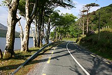
Both the road systems in Ireland and Northern Ireland are very extensive. Historically, Northern Ireland's roads are of better quality, even if the renewal of the routes in the Republic of Ireland has reduced the differences. Some country roads across the island are very narrow, have relatively poor pavement, potholes and secluded junctions and curves.
With the support of the European Union , most of Ireland's national roads have been and will be renewed. Until the end of the 1980s, there was only one four-lane road ( dual carriageway ) from Dublin to Naas in the Republic of Ireland . In the meantime (end of 2017) most of the larger cities are connected to the newly built motorway network.
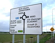
While in Northern Ireland all distances and speeds on road signs are given in miles , in the republic all road signs have been converted to kilometers over a period of 10 years. One began step by step with the distance information. On January 20, 2005, these measures were completed with the speed change.
Classification of the streets
In the Republic of Ireland the roads are classified as follows:
- National roads, marked with N or M, followed by a maximum of 2 digits.
- Regional roads, denoted by R followed by 3 digits.
- Connecting roads, identified by L followed by 4 or 5 digits.
The motorways (marked by M) are all built parallel to the existing national roads (exception M50). After their completion they received their number (N1 → M1), the previous national roads were mainly downgraded to regional roads (N1 → R132). In the case of the N8, the section from Port Laoise to Durrow was renamed the N77 (which already connected Durrow to Kilkenny ). Therefore, unlike in Germany, there are no M and N streets with the same number.
Highways
The Irish motorways ( English motorways , Irish mótarbhealaí ) connect Dublin with the larger cities in the north, west and south. They belong to the national roads and are identified by an M followed by 1 or 2 digits. The numbering starts with the M1 and continues counterclockwise. There is also the M50 , which forms a semicircle around Dublin.
The following table shows the motorways that existed at the end of 2017.
| number | Highway route | target |
|---|---|---|
|
|
Dublin to the north of Dundalk . | Dublin - Belfast |
|
|
Killshane to north of Ashbourne. | Dublin - Derry |
|
|
Dublin to the north of Kells . | Dublin - Ballyshannon |
|
|
Lucan to Mullingar | Dublin - Sligo |
|
|
M4 junction 11 ( Kinnegad ) to the east of Athlone ; west of Athlone to Galway | Dublin - Galway |
|
|
Naas to Limerick . | Dublin - Limerick |
|
|
M7 Junction 19 (c. 15 km southwest of Portlaoise ) to Cork . | Dublin - Cork |
|
|
M7 Junction 11 (about 5 miles south-west of Naas ) to Quarry Roundabout, Grannagh, Co. Waterford | Dublin - Waterford |
|
|
Shankill / Bray bypass; Ashford to south of Gorey . | Dublin - Wexford |
|
|
East of Galway to south of Tuam | Galway - Sligo |
|
|
Shannon to the east of Galway . | Limerick - Galway |
|
|
Outskirts from Limerick City to Patrickswell, (continuation to Cork planned) | Cork - Limerick |
|
|
full route. | Dublin |
National roads
The national primary roads ( national primary roads , príomhbhóithre náisiúnta ) have the prefix N, or M, if they are motorways, followed by a maximum two-digit number, e.g. B. N1 or N67. The main national roads are designated N1 to N11 (numbered counterclockwise from Dublin).
Interurban roads
Overland roads ( national secondary roads , bóithre náisiúnta den dara grád ) have numbers beyond N50. The only exception is the ring road around Dublin, which bears the name N50 in addition to the designation M50.
Country roads
Roads ( regional roads , bóithre réigiúnacha ) begin with the letter R. The numbering is performed by R1 (in the northeast) to R7xx (in the south east of Ireland). The bandwidth of these roads ranges from two-lane carriageways with a median to almost single-lane roads. All other "streets" are usually not identified with a number; officially these streets are registered with the letter L and four or five digits. Some old streets still have the old names that begin with a T ( trunk road , mórbhóthar ) or an L ( link road , bóthar ceangail ).
Allowed speeds
The following speeds apply on the roads in the Republic of Ireland.
- 120 km / h on motorways.
- On national roads 100 km / h.
- 80 km / h on regional and connecting roads.
- Within localities 50 km / h.
- In addition, limits of 30 km / h or 60 km / h may be prescribed in certain zones.
When switching from miles to kilometers, traffic signs for the legally permitted speed were set up on all roads. On the way out of town, for example, there are signs for 80 km / h on a narrow field path that is considered a connecting road.
Web links
- Map of the motorways and national roads (as of 2016)
- Opening of the M17 / M18 motorways in September 2017
- Environmental influences from the expansion of the M50 - including the course plan and models of the expanded driveways ( Memento from April 3, 2005 in the Internet Archive ) (PDF; 3.4 MB)
Individual evidence
- ↑ Traffic signs: change to metric information . Retrieved December 23, 2017.
- ↑ Speed Limits . Retrieved December 28, 2017.


