Promau (Hollenstein an der Ybbs)
| Großpromau ( single shift ) | ||
|---|---|---|
|
|
||
| Basic data | ||
| Pole. District , state | Amstetten (AM), Lower Austria | |
| Judicial district | Amstetten | |
| Pole. local community | Hollenstein an der Ybbs ( KG Garnberg) | |
| Locality | Oberkirchen | |
| Coordinates | 47 ° 45 '49 " N , 14 ° 49' 41" E | |
| height | 773 m above sea level A. | |
| Building status | 1 (2001) | |
| Post Code | 3343 | |
| Statistical identification | ||
| Counting district / district | Hollenstein area (30516 001) | |
| Source: STAT : index of places ; BEV : GEONAM ; NÖGIS | ||
Promau is a valley in the Ybbstal Alps , here are the settlements Großpromau and Kleinpromau , which belong to the municipality of Hollenstein an der Ybbs in the Scheibbs district , Lower Austria .
geography
| Kleinpromau ( one shift ) | |
|---|---|
| Basic data | |
| Pole. District , state | Amstetten (AM), Lower Austria |
| Judicial district | Amstetten |
| Pole. local community | Hollenstein an der Ybbs ( KG Garnberg) |
| Locality | Oberkirchen |
| Coordinates | 47 ° 45 ′ 40 " N , 14 ° 49 ′ 45" E |
| height | 809 m above sea level A. |
| Building status | 1 (2001) |
| Post Code | 3343 |
| Statistical identification | |
| Counting district / district | Hollenstein area (30516 001) |
| Source: STAT : index of places ; BEV : GEONAM ; NÖGIS | |
The Promau area is a pass landscape between the Göstlinger Mendlingtal and the Hollensteiner Hammerbachtal and Sandgraben . This valley line separates the Königsberg range ( 1,452 m above sea level ) in the north from the Gamsstein range (Hochkogel 1,774 m above sea level , Voralpe group ), two massifs of the Ybbstaler Voralpen . The first is still a largely wooded ridge, the second is an alpine limestone stock that is bare in the summit region.
The Promau is a clearing island of the two farms, and is otherwise surrounded by forest.
Neighboring places
| Wenten |
Koenigsberg (Thomasberg) |
|

|
Großegg (Gem. Göstling an der Ybbs , District Scheibbs ) | |
|
( Scheibenberg ) Mendling (Gem. Göstling an der Ybbs , District Scheibbs and Gem. Landl , District Liezen , Styria ) |
Lassing (Gem. Göstling an der Ybbs , District Scheibbs ) |
Promau pass
|
||||||||||||||||||||||||||||||||||||
history
The route Lassing - Großhollenstein was an important transport route for iron ore pig iron to the small iron trade region around Hollenstein and Opponitz , and as such a side route of the Eisenstraße to the three-market district Gresten , Scheibbs and Purgstall an der Erlauf (or Scheibbs, Purgstall, Göstling).
Nature and sights
The valley lies in the [ Lower Austrian ] Eisenwurzen nature reserve . The area is easy hiking and mountain biking terrain, forest trails can be used to climb the surrounding mountains.
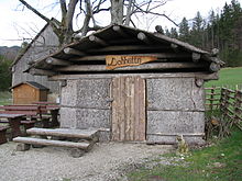
To the west is the listed Sandgraben hunting lodge , to the east is the adventure world Auf dem Holzweg in Mendlingtal , which documents the Eisenwurzen small iron trade with several systems. In this direction there is also the Lohhütte on the road , a bark hut ( Forstleutehütte) that was reconstructed by the nature park administration and is typical of Eisenwurzen .
Individual evidence
- 30516 - Hollenstein on the Ybbs. Community data, Statistics Austria .
- ↑ a b not noted in the ÖK , for local usage compare Promau: Lohhütte , naturpark-eisenwurzen.at; For more photos of this nature park attraction , see Lohhütte , say.at »Themes» Wood »Wooden houses
- ↑ 809 m level ÖK ; Atlas map: Terrain height: (laser scan) → Coordinate measurement gives 802 m for the pass height
-
^ Franz Eppel : Die Eisenwurzen (= Austrian art monograph . Volume 4 ). 2nd Edition. Verlag St. Peter, Salzburg 1968, ISBN 3-900173-04-4 ( Bibl. Entry , eisenstrasse.info). ;
Edith Bilek-Czerny: Most- und Eisenstraße (= messages from Lower Austria. Issue 9-2002; Preservation of monuments in Lower Austria . Volume 28 ). 2nd Edition. Office of the Lower Austrian State Government, Department for Culture and Science, 2002, DNB 967091276 , p. 44 . - ↑ see Eisenwurzen / hiking tips , naturparke.at
- ↑ see mountain biking , naturpark-eisenwurzen.at


