Bazentin
| Bazentin | ||
|---|---|---|

|
|
|
| region | Hauts-de-France | |
| Department | Somme | |
| Arrondissement | Péronne | |
| Canton | Albert | |
| Community association | Pays du Coquelicot | |
| Coordinates | 50 ° 2 ′ N , 2 ° 46 ′ E | |
| height | 94-159 m | |
| surface | 5.10 km 2 | |
| Residents | 79 (January 1, 2017) | |
| Population density | 15 inhabitants / km 2 | |
| Post Code | 80300 | |
| INSEE code | 80059 | |
| Website | www.paysducoquelicot.com | |
 view |
||
Bazentin ( Picard : Bazintin) is a northern French municipality with 79 inhabitants (at January 1, 2017) in the department of Somme in the region of Hauts-de-France . The municipality belongs to the canton of Albert and is part of the Communauté de communes du Pays du Coquelicot .
geography
The municipality, located ten kilometers northeast of Albert im Santerre , is on the departmental roads D20 and D73. The hamlet of Bazentin-le-Grand belongs to the municipality, whose main part today forms the former Bazentin-le-Petit.
history
The parish was destroyed in the Battle of the Somme in July 1916. She received the Croix de guerre 1914–1918 as an award .
Residents
| 1962 | 1968 | 1975 | 1982 | 1990 | 1999 | 2006 | 2010 |
|---|---|---|---|---|---|---|---|
| 130 | 114 | 82 | 74 | 70 | 77 | 68 | 76 |
administration
Mayor (maire) has been Jean-Luc Fourdinier since 2001.
Attractions
- The rebuilt Church of the Birth of Mary, originally from 1774, with a lectern from the 17th century.
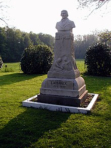
- Lamarck monument
- Two British war cemeteries
Personalities
Jean-Baptiste de Lamarck , botanist and zoologist, born in Bazentin-le-Petit in 1744, died in 1829

