
Étinehem-Méricourt
| Étinehem-Méricourt | ||
|---|---|---|
|
||
| region | Hauts-de-France | |
| Department | Somme | |
| Arrondissement | Péronne | |
| Canton | Albert | |
| Community association | Pays du Coquelicot | |
| Coordinates | 49 ° 56 ' N , 2 ° 41' E | |
| height | 32-103 m | |
| surface | 18.22 km 2 | |
| Residents | 592 (January 1, 2017) | |
| Population density | 32 inhabitants / km 2 | |
| Post Code | 80340 | |
| INSEE code | 80295 | |

Étinehem-Méricourt is a municipality in France . It belongs to the Somme in the region of Hauts-de-France and the canton of Albert in Arrondissement Péronne . It was created on January 1, 2017 as Commune nouvelle through the amalgamation of Étinehem and Méricourt-sur-Somme by decree of July 11, 2016. These have been Communes déléguées since then . Étinehem is the main town (chief-lieu).
structure
| District | former INSEE code |
Area (km²) | Population (2016) |
|---|---|---|---|
| Étinehem (administrative headquarters) | 80295 | 11.08 | 372 |
| Méricourt-sur-Somme | 80532 | 7.14 | 215 |
geography
Étinehem lies north and Méricourt south of the Somme , which meanders there . Neighboring municipalities are Méaulte in the north, Bray-sur-Somme and La Neuville-lès-Bray in the east, Proyart and Morcourt in the south and Chipilly and Morlancourt in the west.
Attractions
- Churches of Saint-Martin in Méricourt and Saint-Pierre in Étinehem
- War memorial in Étinehem
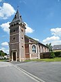
Saint Martin Church
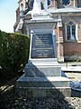
War memorial

Saint-Pierre church
.JPG)
.JPG)
.JPG)
Web links
Commons : Étinehem-Méricourt - collection of images, videos and audio files
Individual evidence
- ↑ Population figures retrospectively from January 1, 2016