Heudicourt (Somme)
| Heudicourt | ||
|---|---|---|
|
|
||
| region | Hauts-de-France | |
| Department | Somme | |
| Arrondissement | Péronne | |
| Canton | Péronne | |
| Community association | Haute Somme | |
| Coordinates | 50 ° 1 ′ N , 3 ° 5 ′ E | |
| height | 107-144 m | |
| surface | 12.71 km 2 | |
| Residents | 507 (January 1, 2017) | |
| Population density | 40 inhabitants / km 2 | |
| Post Code | 80122 | |
| INSEE code | 80438 | |
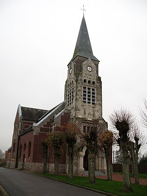
 The Saint-Rémi church |
||
Heudicourt (Picard: Vidicourt ) is a French municipality with 507 inhabitants (at January 1, 2017) in the department of Somme in the region of Hauts-de-France in northern France. The municipality belongs to the canton of Péronne .
geography
The municipality is located on the departmental roads D58 (part of the system of Chaussée Brunehaut ) and D181 from Péronne towards Cambrai about 3.5 km east of Fins and 4.5 km northwest of Épehy in Vermandois . The Ferme Révelon to the northeast is part of Heudicourt. The community used to have a railway connection to Épehy (remnants of the embankment can still be seen on the IGN map).
Residents
| 1962 | 1968 | 1975 | 1982 | 1990 | 1999 | 2006 | 2010 |
|---|---|---|---|---|---|---|---|
| 718 | 686 | 629 | 548 | 491 | 502 | 509 | 520 |
administration
Mayor (maire) has been Philippe Butez since 2001.
Attractions
- Saint Rémi Church (20th century)
- british war cemetery
- Brickyard Houchet
- former sugar factory in Révelon
- former Belfort Légère weaving mill
- Le Crin weaving mill
- underground protective structures ( muche ; cf. Naours )
Web links
Commons : Heudicourt - collection of images, videos and audio files
