Maricourt (Somme)
| Maricourt | ||
|---|---|---|
|
|
||
| region | Hauts-de-France | |
| Department | Somme | |
| Arrondissement | Péronne | |
| Canton | Albert | |
| Community association | Pays du Coquelicot | |
| Coordinates | 49 ° 59 ′ N , 2 ° 47 ′ E | |
| height | 55-129 m | |
| surface | 7.52 km 2 | |
| Residents | 178 (January 1, 2017) | |
| Population density | 24 inhabitants / km 2 | |
| Post Code | 80360 | |
| INSEE code | 80513 | |
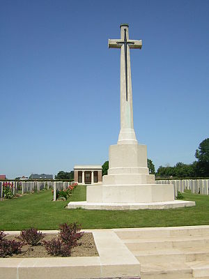
 Maricourt Military Cemetery |
||
Maricourt is a northern French municipality with 178 inhabitants (at January 1, 2017) in the department of Somme in the region of Hauts-de-France . The municipality belongs to the canton of Albert and has been part of the Communauté de communes du Pays du Coquelicot since January 1, 2013 (previously Communauté de communes du canton de Combles ).
geography

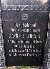
Obersülzen cemetery , Rhineland-Palatinate ; Gravestone of a soldier of the 17th Bay who fell at Maricourt . Inf. Rgts.
The municipality is located around 14.5 km west-northwest of Combles on the D938 departmental road from Combles to Albert on the Circuit de Souvenir, which commemorates the Battle of the Somme in 1916. It extends in the south into the valley of the Somme, which meanders here .
history
The community received the Croix de guerre 1914-1918 as an award .
Residents
| 1962 | 1968 | 1975 | 1982 | 1990 | 1999 | 2006 | 2017 |
|---|---|---|---|---|---|---|---|
| 202 | 187 | 165 | 146 | 137 | 145 | 153 | 178 |
Attractions
- British war cemetery
Personalities
- Petrus Peregrinus de Maricourt , scientist of the 13th century
- Augustin Cochin, historian, born in 1876, died on July 8, 1916 in Maricourt at the Battle of the Somme
Web links
Commons : Maricourt - collection of images, videos and audio files
