Harponville
| Harponville | ||
|---|---|---|
|
|
||
| region | Hauts-de-France | |
| Department | Somme | |
| Arrondissement | Péronne | |
| Canton | Albert | |
| Community association | Pays du Coquelicot | |
| Coordinates | 50 ° 2 ′ N , 2 ° 30 ′ E | |
| height | 69-147 m | |
| surface | 2.75 km 2 | |
| Residents | 180 (January 1, 2017) | |
| Population density | 65 inhabitants / km 2 | |
| Post Code | 80560 | |
| INSEE code | 80420 | |
| Website | www.paysducoquelicot.com | |
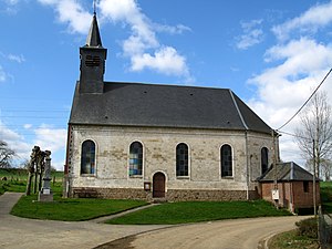
 Church and war memorial |
||
Harponville is a northern French municipality with 180 inhabitants (at January 1, 2017) in the department of Somme in the region of Hauts-de-France . The municipality belongs to the canton of Albert and is part of the Communauté de communes du Pays du Coquelicot .
geography
Harponville is located around six kilometers southwest of Acheux-en-Amiénois on the D47 to Contay . A dry valley leads to Hallue near Harponville .
history
In the late Middle Ages, the community was under the influence of the Abbey of Saint-Riquier ( Centula ), while the nearby, abandoned town of Hierville was under the control of the Abbey of Corbie . The rule came to the de Raincheval family in 1683, with whom Protestant influence spread. The Protestant church was built in 1823 and a new one after a fire in 1863. In the First World War fortifications were built, otherwise the war as well as who had World War II on Harponville little effect.
Residents
| 1962 | 1968 | 1975 | 1982 | 1990 | 1999 | 2006 | 2010 |
|---|---|---|---|---|---|---|---|
| 177 | 160 | 151 | 150 | 130 | 125 | 148 | 168 |
administration
Mayor (maire) has been Dominique Renaud since 2001.
Attractions
- Church of Sainte Trinité from the 19th century
- Protestant Church
- War memorial with croix de guerre
- British war cemetery

