Hombleux
| Hombleux | ||
|---|---|---|
|
|
||
| region | Hauts-de-France | |
| Department | Somme | |
| Arrondissement | Péronne | |
| Canton | Ham | |
| Community association | Est de la Somme | |
| Coordinates | 49 ° 44 ′ N , 2 ° 59 ′ E | |
| height | 52-76 m | |
| surface | 15.81 km 2 | |
| Residents | 1,180 (January 1, 2017) | |
| Population density | 75 inhabitants / km 2 | |
| Post Code | 80400 | |
| INSEE code | 80442 | |
Hombleux is a French commune with 1,180 inhabitants (at January 1, 2017) in the department of Somme in the region of Hauts-de-France in northern France. It is the second largest municipality in the canton of Ham .
It was created as the Commune nouvelle of the same name with effect from January 1, 2019 through the amalgamation of the previous municipalities Hombleux and Grécourt , which were not granted the status of a Commune déléguée in the new municipality . The administrative headquarters are in Hombleux.
structure
| District | former INSEE code |
Area (km²) | Population (2016) |
|---|---|---|---|
| Grécourt | 80389 | 2.34 | 21st |
| Hombleux (administrative headquarters) | 80442 | 13.47 | 1,152 |
geography
The municipality is located on the D930 département road from Nesle, 8 km to the west, to Ham , south of the Canal de la Somme and east of the Canal du Nord . The hamlet of Bacquencourt belongs to Hombleux and extends as far as the Petit Ingon , but does not reach the Canal du Nord, and which is connected to Breuil by a bridge .
Sightseeing
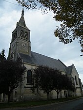
- Church Saint-Médard
Web links
Individual evidence
- ↑ Decree of the Prefecture No. 80-2018-12-07-003 on the formation of the Commune nouvelle Hombleux of December 7, 2018.
- ↑ Population figures retrospectively from January 1, 2016

