Courcelette
| Courcelette | ||
|---|---|---|
|
|
||
| region | Hauts-de-France | |
| Department | Somme | |
| Arrondissement | Péronne | |
| Canton | Albert | |
| Community association | Pays du Coquelicot | |
| Coordinates | 50 ° 4 ′ N , 2 ° 45 ′ E | |
| height | 109-156 m | |
| surface | 4.66 km 2 | |
| Residents | 154 (January 1, 2017) | |
| Population density | 33 inhabitants / km 2 | |
| Post Code | 80300 | |
| INSEE code | 80216 | |
| Website | www.paysducoquelicot.com | |
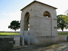
 The Canadian monument |
||
Courcelette ( Picard : Corchlette) is a northern French municipality with 154 inhabitants (at January 1, 2017) in the department of Somme in the region of Hauts-de-France . The municipality belongs to the canton of Albert and is part of the Communauté de communes du Pays du Coquelicot .
geography
The municipality, which lies on the border of Picardy and Artois and whose territory is bounded in the southwest by the D929 département road (former Route nationale 29 ) from Amiens via Albert to Bapaume , is around 9 km northwest of Albert.
history
In the Middle Ages, the municipality was under the rule of the Lords of Courcelette. During World War I , it was one of the scenes of the Battle of the Somme from September to November 1916.
Residents
| 1962 | 1968 | 1975 | 1982 | 1990 | 1999 | 2006 | 2010 |
|---|---|---|---|---|---|---|---|
| 202 | 180 | 176 | 150 | 142 | 133 | 138 | 147 |
administration
Mayor (maire) has been Xavier Vandendriessche since 2001.
Attractions
- Saint-Ultan church
- Canadian Memorial on the D929
- British war cemetery on the way to Thiepval

