Estrées-Mons
|
Estrées-Mons Étrée-Mon |
||
|---|---|---|
|
|
||
| region | Hauts-de-France | |
| Department | Somme | |
| Arrondissement | Péronne | |
| Canton | Péronne | |
| Community association | Haute Somme | |
| Coordinates | 49 ° 53 ' N , 3 ° 0' E | |
| height | 56-102 m | |
| surface | 15.3 km 2 | |
| Residents | 606 (January 1, 2017) | |
| Population density | 40 inhabitants / km 2 | |
| Post Code | 80200 | |
| INSEE code | 80557 | |
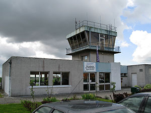
 Tower of the Péronne airfield in Estrées-Mons |
||
Estrées-Mons ( Picard : etree-Mon) is a French municipality with 606 inhabitants (at January 1, 2017) in the department of Somme in the region of Hauts-de-France in northern France. The municipality belongs to the canton of Péronne and is part of the Communauté de communes de la Haute Somme .
geography
The community, made up of the former communities of Mons-en-Chaussée and Estrées-en-Chaussée, is located north of the Omignon valley, around 9 km southeast of Péronne on the D1029 département road ( Chaussée Brunehaut ). Districts (of Mons-en-Chaussée) are Prusles and St-Cren. The Péronne-Saint Quentin airfield is located in the commune (partly on the territory of the commune of Monchy-Lagache ) .
history
The community, which was destroyed in World War I , was awarded the Croix de guerre 1914–1918.
In 1973 the municipalities of Estrées-en-Chaussée and Mons-en-Chaussée merged to form the new municipality of Estrées-Mons.
Population development
| 1962 | 1968 | 1975 | 1982 | 1990 | 1999 | 2006 |
|---|---|---|---|---|---|---|
| 536 | 520 | 628 | 631 | 596 | 609 | 581 |
administration
Mayor ( Maire ) has been Jean-Paul Colard since 2001.
