
Claudon
| Claudon | ||
|---|---|---|
.svg)
|
|
|
| region | Grand Est | |
| Department | Vosges | |
| Arrondissement | Neufchâteau | |
| Canton | Darney | |
| Community association | Vosges Côté Sud Ouest | |
| Coordinates | 48 ° 2 ′ N , 6 ° 2 ′ E | |
| height | 248-404 m | |
| surface | 21.72 km 2 | |
| Residents | 216 (January 1, 2017) | |
| Population density | 10 inhabitants / km 2 | |
| Post Code | 88410 | |
| INSEE code | 88105 | |
 Monastery church in the Droiteval district |
||

Claudon is a French commune in the Vosges department in the region of Grand Est . It belongs to the Arrondissement of Neufchâtea and the Canton of Darney .
geography
The community of Claudon, with 216 inhabitants (January 1, 2017), is located at an average altitude of around 310 m above sea level, 35 kilometers southwest of Épinal and 25 kilometers southeast of Vittel in the extreme south of Lorraine on the border with the Franche-Comté region .
The municipal area of 21.72 km² is located on the Vôge plateau in the catchment area of the upper Saône . The Ourche flows through the municipality and flows into the Saône in the north-west.

By far the largest part of the communal area belongs to the Forêt Domaniale de Darney , one of the largest contiguous mixed forest areas in Lorraine. Agricultural areas can only be found on the clearing islands around the core town and around the districts. Claudon includes the hamlets of Droiteval, La Grande Catherine, La Grange Rouge, La Sybille and Henricel .
The neighboring communities of Claudon are Attigny in the north, Hennezel in the east, Passavant-la-Rochère in the southeast, Martinvelle in the south and Monthureux-sur-Saône in the west.
history
The village was laid out by a Celtic tribe on a rocky promontory above the ore. The Celtic name Clando gradually became Claudon as part of the Bailiwick of Darney and the Duchy of Lorraine . The founding of the Cistercian Abbey Notre Dame de Droiteva ( Droiteval Monastery ) in 1130 was decisive for the development of the area. After monasteries and priories were built everywhere in Lorraine, the Duke of Lorraine ordered glassworks to be built in the vast forests around Darney in 1448 . The glassmakers settled near the glassworks, widely scattered in the area around Claudon and Hennezel . Baptisms, weddings and funerals were celebrated in Attigny . Claudon only received his own parish on November 15, 1763 with the completion of the Church of St. Guarinus (Saint-Guérin)
With the settlement of mills and forges, Claudon gradually established itself as a small industrial center. On the eve of the French Revolution, there were eleven glassworks, seven royal blacksmiths, three mills, a sawmill and a tile factory in the Claudon community . Since the decline of these early industries, the community has been more agricultural and forestry.
Population development
| year | 1962 | 1968 | 1975 | 1982 | 1990 | 1999 | 2006 | 2017 | |
| Residents | 362 | 376 | 308 | 285 | 238 | 262 | 220 | 216 | |
| Sources: Cassini and INSEE | |||||||||
Attractions
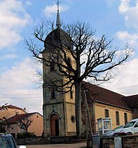
- Church of St. Guarinus (Saint-Guérin) from 1765 with a tower from 1881
- Liberty oak next to the church from 1790
- Cistercian Abbey of Notre Dame de Droiteval ( Droiteval Monastery ) founded in 1130
- Pont Tatal , a viaduct over the Ourche the 1964 decommissioned and mainly used by the military railway line con Jussey by Uxegney , with a platform for since 1998 bungee jumpers equipped
- Church of St. Guarinus in Claudon


Economy and Infrastructure
There are seven farms in the municipality (dairy, goat and sheep breeding).
The road leads through Claudon from Darney via Passavant-la-Rochère to Corre . The nearest train stations are in Bains-les-Bains and Contrexéville .
supporting documents
- ↑ History abstract on claudon.pagesperso-orange.fr (French)
- ↑ Claudon on cassini.ehess.fr
- ↑ Claudon on insee.fr
- ↑ Farms on annuaire-mairie.fr (French)