
Alabama
| Alabama | |||||
|---|---|---|---|---|---|
| |||||
  | |||||
| Capital: | Montgomery | ||||
| State motto: | Audemus jura nostra defendere | ||||
| Official language : | English | ||||
| Area: | 135,765 km² | ||||
| Residents: | 4,908,620 (2020) (35 U / km²) | ||||
| Member since: | December 14, 1819 | ||||
| Time zone: |
UTC − 6 ( CST ) UTC − 5 (daylight saving time) |
||||
| The highest point: | 734 m ( Cheaha Peak ) | ||||
| Average Height: | 152 m | ||||
| Deepest point: | 0 m Gulf of Mexico | ||||
| Governor : | Kay Ivey ( R ) | ||||
| Post / Office / ISO | AL / Ala. / US-AL | ||||
 | |||||


Alabama [ æləˈbæmə ] ( American pronunciation ) is a state of the United States , one of the southern states . For a long time it was shaped by the plantation agriculture of a small white upper class and by the slavery of the African Americans , who make up about a quarter of the population. After the end of the Reconstruction, the interests of the agrarian elite continued through discrimination such as racial segregation into the 1970s. After the Second World War, the state's economy diversified, which is still one of the poorest in the country.
Surname
The name "Alabama" goes back to the French name of the Indian tribe from the Muskogee language family known today as the Alabama . The French-born settlers called them "Alibamons" in an attempt to reproduce a word from the Choctaw language that sounded similar to their ears. This word in turn denoted the activity of cutting and gathering herbs or grasses.
The Alabama tribe was first mentioned in 1540 by participants in the Hernando de Sotos expedition . Garcilasso de la Vega called it the Alibamo , others called it Alibamu or Limamu The French called it Alibamons in 1702 , accordingly the river was called Rivière des Alibamons on French maps .
Alabama has the unofficial nicknames Cotton State ( German cotton state ), Yellowhammer State (German gold woodpecker state ) and Heart of Dixie (German heart of the south ).
geography
Position and extent
With an area of 135,765 km², Alabama ranks 30th among the US states . It is bordered by Tennessee to the north, Georgia to the east, Mississippi to the west, and Florida to the southeast . To the northeast are the stony Appalachian Mountains , and between the Coosa River and Auburn the Piedmont plateau with red, iron-rich clay soil; in the south and west lies the predominantly sandy coastal plain of the Gulf of Mexico. The area around Montgomery and Selma has particularly fertile, dark alluvial soil. Much of the area of the state is covered by forest. In the south lies the Gulf of Mexico , into which the main Alabama River flows. Alabama is divided into 67 counties .
Alabama has a national monument : Russell Cave National Monument
structure
climate
| Average high and low temperature for various cities in Alabama (° C) | |||||||||||||||
|---|---|---|---|---|---|---|---|---|---|---|---|---|---|---|---|
| month | Jan | Feb | Mar | Apr | May | Jun | Jul | Aug | Sep | Oct | Nov | Dec | year | ||
| Huntsville | avg. Maximum temp. | 9.4 | 12.6 | 17.4 | 22.4 | 26.4 | 30.3 | 31.9 | 31.7 | 28.3 | 22.7 | 16.4 | 11.3 | 21.7 | |
| avg. Lowest temp. | −0.7 | 1.1 | 5.1 | 9.1 | 14.2 | 18.6 | 20.8 | 20.1 | 16.5 | 9.8 | 4.8 | 1.0 | 10.1 | ||
| Birmingham | avg. Maximum temp. | 11.6 | 14.6 | 19.2 | 23.4 | 27.2 | 30.8 | 32.6 | 32.3 | 29.2 | 23.8 | 18.1 | 13.3 | 23.0 | |
| avg. Lowest temp. | 0.2 | 1.9 | 5.8 | 9.1 | 14.2 | 18.6 | 20.9 | 20.5 | 17.2 | 10.5 | 5.4 | 1.8 | 10.5 | ||
| Montgomery | avg. Maximum temp. | 14.2 | 16.9 | 21.4 | 25.3 | 29.2 | 32.6 | 33.7 | 33.4 | 30.9 | 25.9 | 20.4 | 15.7 | 25.0 | |
| avg. Lowest temp. | 1.9 | 3.7 | 7.4 | 11.2 | 15.6 | 19.6 | 21.6 | 21.2 | 18.3 | 11.2 | 6.4 | 3.1 | 11.8 | ||
| mobile | avg. Maximum temp. | 15.9 | 18.1 | 21.8 | 25.2 | 29.0 | 31.9 | 32.9 | 32.7 | 30.4 | 26.2 | 21.2 | 17.2 | 25.2 | |
| avg. Lowest temp. | 4.2 | 5.8 | 9.6 | 12.7 | 17.1 | 20.7 | 22.1 | 22.0 | 19.8 | 13.5 | 8.8 | 5.3 | 13.4 | ||
| Source: NOAA | |||||||||||||||
Hurricanes
| date | Surname | Affected area | Wind speed | Damage in $ | Victim |
|---|---|---|---|---|---|
| September 19, 1906 | Hurricane Mississippi | Coastal region | 151 km / h | $ 2.7 billion | 134 dead |
| September 13, 1975 | Hurricane Eloise | 193 km / h | $ 2.1 billion | 80 dead | |
| September 12, 1979 | Hurricane Fredric | Coastal region | 215 km / h | $ 4-8 billion | 14 dead |
| 4th October 1995 | Hurricane Opal | Coastal region | 240 km / h | $ 5 billion | 59 dead |
| July 18, 1997 | Hurricane Danny | Coastal region | 130 km / h | $ 100 million | 10 dead |
| September 28, 1998 | Hurricane Georges | Coastal region | 250 km / h | $ 6 billion | 603 dead |
| September 16, 2004 | Hurricane Ivan | Coastal region | 270 km / h | $ 20 billion | 124 dead |
| August 29, 2005 | Hurricane Katrina | Coastal region | 280 km / h | > $ 80 billion | 1834 dead |
population

Alabama has 4,779,736 inhabitants (as of the 2010 census), of which 70.4% are white , 26.3% black or African American , 2.3% Hispanic or Latino , 1.0% Asian American and 0.4% American Indian .
Religions
The most important religious communities in 2000:
1,380,121 Southern Baptist Convention , 327,734 United Methodist Church , 150,647 Catholic Church
There are many other, mainly Protestant, denominations.
Age and gender structure
The age structure of Alabama is made up as follows:
- up to 18 years: 1,115,668 (24.2%)
- 18–64 years: 2,872,991 (62.5%)
- from 65 years: 610,371 (13.3%)
The median age is 37.2 years. 48.5% of the population are male and 51.5% are female.
ancestry
16.7% of the population are of American descent , making them the largest group. This is followed by the Irish (9.1%), English (7.6%) and German-born (6.7%) groups (as of 2014).
Population development
| Population development | |||
|---|---|---|---|
| Census | Residents | ± in% | |
| 1800 | 1250 | - | |
| 1810 | 9046 | 623.7% | |
| 1820 | 127.901 | 1,313.9% | |
| 1830 | 309,527 | 142% | |
| 1840 | 590.756 | 90.9% | |
| 1850 | 771.623 | 30.6% | |
| 1860 | 964.201 | 25% | |
| 1870 | 996.992 | 3.4% | |
| 1880 | 1,262,505 | 26.6% | |
| 1890 | 1,513,401 | 19.9% | |
| 1900 | 1,828,697 | 20.8% | |
| 1910 | 2,138,093 | 16.9% | |
| 1920 | 2,348,174 | 9.8% | |
| 1930 | 2,646,248 | 12.7% | |
| 1940 | 2,832,961 | 7.1% | |
| 1950 | 3,061,743 | 8.1% | |
| 1960 | 3,266,740 | 6.7% | |
| 1970 | 3,444,165 | 5.4% | |
| 1980 | 3,893,888 | 13.1% | |
| 1990 | 4,040,587 | 3.8% | |
| 2000 | 4,447,100 | 10.1% | |
| 2010 | 4,779,736 | 7.5% | |
| Before 1900
1900-1990 2000 |
|||
The following figures are taken from the US Census database; The Census did not take a census of the native inhabitants of the territory, which in particular in the years before the Treaty of Cusseta , which provided for the implementation of the Indian Removal Act , made up a considerable proportion of the total population.
education
The largest state universities include the 3 locations of the University of Alabama System , as well as Auburn University , the University of North Alabama , the University of South Alabama , the University of West Alabama and the Jacksonville State University . Additional colleges can be found on the list of universities in Alabama .
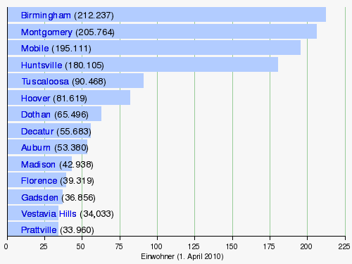
Biggest cities
story
Early history
Paleo-Indians
The arrival of the first humans is believed to have been around 9500 BC. Adopted. The sea level was considerably lower than it is today, so that the coastline ran further south. North of the Montevallo valley, the dense coniferous forest turned into an oak- hickory forest, south of it this type of forest had existed for a long time. People hunted the sometimes huge representatives of the megafauna , which soon became extinct, but also rabbits and other mammals, as well as birds. The north of Alabama seems to have had greater importance for longer stays in the long-range migrations of the small groups, perhaps 25 to 50 people. In addition to Clovis blades, there were those of the Redstone , Quad (after a site on the Tennessee River , where more than 200 blades were found) and Beaver Lake were found . The most important site is the Dust Cave (approx. 8500 BC), a cave near Florence .
Archaic period
From about 8500 to 3000 BC Remains of the Archaic period can be found in Alabama. Around 8500 BC BC changed the previously cool climate to a much warmer one. The hunter-gatherer groups probably lived in small family groups. The nomadic groups gathered the fruits of Hickory, then acorns and chestnuts, were added, Muscadinia rotundifolia (a Weinrebenart) and Persimmons, a yellow fruit that the Powhatan blackberries pessamin called, and the genus Diospyros belong, and pokeweed or pokeweed . Deer , turkey , squirrels , raccoons , rabbits, turtles, snakes, small birds and numerous species of fish were hunted . Their food scraps piled up to so-called middens , which were up to 5 m high, and which were mostly on the rivers. Arthritis can also be detected in early groups , along with healed bone fractures that required care from the relatives; only a few were considerably older than 40 years.
On the basis of the projectile points , the Archaic Period is divided into an early (around 8500 to 6000 BC), middle (up to 4000 BC) and later phase (up to 1000 BC). The more favorable living conditions led to a considerable increase in the number of residents who lived together in groups of 50 to 150 people. The temperature in the middle archaic phase was considerably higher than today, and the area was also drier. During this time long-distance trade routes emerged, for example to get to Flint from northeast Alabama; wars can be proven for the first time, as skeletons were found in which projectile points were still stuck. At the same time, the settlements became larger.
From around 4000 BC The temperature sank to about today's level. The number of settlements, especially in the southeast, increased significantly. Also in the valleys of Tennessee, Tombigbee and Alabama River more people settled. Pottery was first made around 1500 BC. BC, a technique likely adopted from Georgia and South Carolina ; They also experimented with horticulture. So pumpkin, sunflower and corn were grown. Long-distance trade increased in numbers, including soapstone, greenstone and mica from eastern Alabama.
Woodland period
The changes in the now more sedentary population represented such a drastic change that the woodland period began for archeology. One of the largest sites next to Moundville (20 km south of Tuscaloosa ), which was formed around 1120, had more than 1000 inhabitants and contained 29 mounds that rose up to 20 m, is the Bottle Creek site , which has been a National Historic Landmark since 1995 who found at least 18 mounds. This place was the center of the Pensacola culture from around 1250 , the traces of which stretch from Choctawhatchee Bay in western Florida to the east bank of the Mississippi Delta in Louisiana . It was closely related to the Mississippi culture that began around 900 and the Moundville people of the Black Warrior River , and reached the greatest density in Mobile Bay in the Mobile Tensaw Delta and in the southern parts of the Tombigbee and Alabama Rivers .
Choctaw, Creek, Chickasaw, Cherokee
Four Native American groups were significant to Alabama: the Chickasaw , Choctaw , Muskogee, and Cherokee .
Around 1800 the Choctaw were one of the largest Indian groups in the south with around 15,000 members. They lived in about 50 villages in western Alabama and Mississippi . Of the three large groups, only the eastern part lived partly in Alabama, mainly on the upper Chickasawhay River and on the lower Tombigbee . Only between 1540 and 1699 did the three groups move to the common area, with the Alabama group probably being associated with Moundville. Early on, the need for slaves in European sugar cane plantations gave rise to wars, such as the Creek and Chickasaw, which once captured 2,000 Choctaws using European weapons and sold them as slaves to the British West Indies . When the French settled in Biloxi , the Choctaw acquired rifles from them, which they used to defend themselves. When the French had to give up North America in 1763, the Choctaw intensified their trade contacts with the British, which were also defeated. In 1784 they signed a peace treaty with Spain and in 1786 with the USA. In the Treaties of Fort Confederation of 1802 and Mount Dexter of 1805, they had to cede large tracts of land. In 1826 the Choctaw adopted a constitution. Despite economic and political efforts, they were forced to give up their land east of the Mississippi in 1830 (Treaty of Dancing Rabbit Creek).
The Muskogee (Creek), the second powerful tribal union, had to give up the land in 1830 and move west, they too go back to the Mississippi culture. In the 16th century, Spanish violence and, above all, epidemics had dispersed the groups there, which were only able to organize themselves again in the 17th century. Some groups settled on the Chattahoochee River , on the lower Tallapoosa River , and on the middle Coosa River in central eastern Alabama. Around 1680 their number is estimated at 9,000, 100 years later there were around 20,000, in 1830 more than 21,000. They lived in Georgia from 1690 to 1715 , where they began to procure slaves for the plantations. At the same time, they attacked the Spanish in Florida , who almost gave up in 1706. At the end of the 18th century, settlers began to invade their area, and in 1811 she went to Tecumseh to gain support for his Pan-Indian uprising. From 1813 to 1814 they rose against the Americans in the Creek War , but were defeated. In the Treaties of Fort Jackson (1814) and Indian Springs (1825), the Creek had to give up all of their territory in Georgia and move to Alabama. Most of the creeks resisted, but they too had to move west in 1830 ( Path of Tears ).
It wasn't until the late 18th century that some Cherokees moved to northern Alabama. One of their groups, the Chickamauga , was on the British side and moved from the Little Tennessee Hiwassee River in eastern Tennessee to Alabama. They founded two villages near Bridgeport . But they were defeated in 1794 against US troops. In 1806 their land was reduced in size. In 1813/1814 they nevertheless fought on the side of the US troops in the Creek War . By 1817, Tennessee troops terrorized the Cherokee in the Sequatchie and Wills River valleys , for which the US paid the injured party $ 25,500.
Epidemics, Spanish expeditions, colonial powers
The mass extinction was triggered by Spanish invasions that brought smallpox into the country. In 1519 Alonso Álvarez de Pineda landed in Mobile Bay . In 1541 the Spaniard Hernando de Soto reached Alabama from the Appalachians . In 1699 the French came from the south and founded the first colony and in 1702 the city of Fort Louis , which was the capital of the French colony of Louisiana until 1722 . In 1711 the city of Mobile was founded.
In 1763 the English conquered Alabama and in 1779 the Spanish conquered the southern part of Alabama. In 1798, Alabama (with the exception of the coast with the city of Mobile, which was still part of the Spanish Florida ) formed part of the Mississippi Territory . In 1813 Mobile also became part of the territory.
Territory, state, civil war
Four years later, in 1817, Mississippi joined the Union as the 20th state within today's borders, and the remaining area was organized as the Alabama Territory . On December 14, 1819, Alabama finally became the 22nd state in the United States . On January 11, 1861, it left the Union as the fourth state and was one of the founding members of the Confederate States of America on February 4 .
Montgomery , the capital of Alabama, was the first capital of the Confederate States of America between February 4 and May 29, 1861 (in the American Civil War ). On the steps of the Alabama State Capitol , Jefferson Davis took his oath of office.
.svg)
Until the Civil War , in which Alabama took part on the southern side, the state's policy was of the tensions between the poor farmers of the low mountain range in the northeast and the rich plantation owners in the coastal plain, particularly in the so-called Black Belt around Selma and Montgomery with its particularly fertile black soil and good transport routes on the rivers. During the secession , Montgomery served as the capital of the Confederate States of America in the spring of 1861. After the civil war came the era of reconstruction , the military occupation of the south by the north. The animosity towards the north persisted into the late 20th century.
Great Depression and Post-War Era
During the Depression of the 1930s , Alabama was a stronghold of support for Franklin D. Roosevelt's policies . The traditional loyalty to the Democrats that endured from the Reconstruction era mixed with the poverty of large parts of the country to make the New Deal particularly popular. The state also benefited greatly from public investments such as B. by the Tennessee Valley Authority , as both construction and operation of the dams on the Tennessee River in the north of the state created jobs; the Rural Electrification Act (REA) was particularly important for the rural state.
After the Second World War, a period of transformation in Alabama's politics and society began. Here fierce fighting were the segregation fought, and the increasing influence of civil rights to the Democratic party the one hand and by Christian fundamentalism to the Republican party on the other hand resulted in 1955-1985 to a change from a hotbed of a party to a bastion of the other. Martin Luther King and Rosa Parks both lived in Montgomery. The governor George Wallace was also known far beyond the borders of Alabama as an opponent of integration. Economically, with the onset of modernization, an influx of people from the northern states began. It was not until 1967 that Alabama was forced by the Supreme Court to become one of the last states in the United States to lift the ban on mixed marriages .
politics
Constitution
The current constitution of Alabama dates back to 1901. With over 300,000 words and more than 800 amendments added since 1901, it is by far the longest of all US states.
houses of Parliament
The Alabama Parliament, the Alabama Legislature, consists of two houses : the 35-member Senate and the 105-member House of Representatives . Both the senators and the members of the House of Representatives are elected for a four-year term.
governor
The governor of Alabama is the head of the state's executive power, i.e. the head of government. He or she is directly elected for four years. There is a term limit of two terms of office, ie a politician may be in office for a maximum of eight years. The limitation to two terms of office only applies to consecutive periods. If there are breaks in office in between, a governor may be re-elected as often as desired. The constitution stipulates that the governor must deliver a " State of the State Address " to both houses of parliament at least once per legislative term , in which the current state of the state is discussed.
Party politics, political tendencies
| year | republican | Democrats |
|---|---|---|
| 2020 | 62.03% 1,441,170 | 36.57% 849,624 |
| 2016 | 62.08% 1,318,255 | 34.36% 729,547 |
| 2012 | 60.55% 1,255,925 | 38.36% 795,696 |
| 2008 | 60.32% 1,266,546 | 38.80% 813,479 |
| 2004 | 62.46% 1,176,394 | 36.84% 693,933 |
| 2000 | 56.47% 944,409 | 41.59% 695,602 |
| 1996 | 50.12% 769,044 | 43.16% 662,165 |
| 1992 | 47.65% 804,283 | 40.88% 690,080 |
| 1988 | 59.17% 815,576 | 39.86% 549,506 |
| 1984 | 60.54% 872,849 | 38.28% 551,899 |
| 1980 | 48.75% 654,192 | 47.45% 636,730 |
| 1976 | 42.61% 504,070 | 55.73% 659,170 |
| 1972 | 72.43% 728,701 | 25.54% 256.923 |
| 1968 * | 13.99% 146,923 | 18.72% 196,579 |
| 1964 | 69.45% 479,085 | 30.55% 210,732 |
| 1960 | 42.16% 237,981 | 56.39% 318,303 |
| * George Wallace from the American Independent Party won with 65.86% or 691,425 votes |
||
Originally, Alabama was a Democratic bastion as part of Solid South . No Republican won the presidential election between 1828 and 1960 - with the exception of Ulysses S. Grants in 1868 and 1872 . During this period, the Democrats geared their political content to the needs of the agricultural societies of the south, which were dominated by the conservative white upper class. It was only with the onset of the civil rights movement in the 1950s that the Democrats began to liberalize at the federal level and to advocate the elimination of racial segregation. This alienated them in the south from their previous electorate. As in the other states in this region, the Democrats have lost the presidential elections here since 1964 . Only Jimmy Carter , who originally advocated segregation as governor of Georgia , was able to win as a Democrat in 1976 in Alabama. Since then, the Republicans have dominated the conservative state in national elections by a large margin over the Democrats, and the Democratic dominance, which initially continued in regional elections, has also been broken since the 2000s. With the neighboring Mississippi, Alabama has the lowest proportion of swing voters in the country and is therefore hardly influenced by national political trends.
In the meantime, Alabama has changed the structure of its society from a cotton and plantation state to a modern region shaped by industries of the future. Nevertheless, the conservative dominance has been retained there. Only the counties in the so-called Black Belt and the Mississippi Delta region , which have a majority of black voters, are clearly dominated by the Democrats. In addition, the Democrats in the two large cities of Birmingham and Montgomery, which are characterized by steel and mining industries, have better conditions. As of the 2010 election, six out of seven MPs in the US House of Representatives are Republicans. Since the Senate by-election on December 13, 2017 , the Democrats have appointed Doug Jones, for the first time since 1976, a US Senator who represents the state together with Republican Richard Shelby in Congress.
In the Electoral College Alabama provides since 1972 nine electors; In 1968 there were ten.
Members of the 115th Congress
| Surname | Member since | Party affiliation | |
|---|---|---|---|
| Bradley Byrne | 2013 | republican | |
| Martha Roby | 2011 | republican | |
| Mike Rogers | 2003 | republican | |
| Robert B. Aderholt | 1997 | republican | |
| Mo Brooks | 2010 | republican | |
| Gary J. Palmer | 2014 | republican | |
| Terri. A. Sewell | 2010 | democrat |
| Surname | Member since | Party affiliation | |
|---|---|---|---|
| Richard Shelby | 1987 | republican | |
| Doug Jones | 2017 | democrat |
Governors and lieutenant governors
congress
Culture and sights
Museums

The Birmingham Museum of Art in Birmingham, with a collection of around 17,000 objects, is one of the most important art museums in the southeastern United States. Individual collection departments are among the most important of their kind in the United States. Other art museums are the Huntsville Museum of Art in Huntsville , which shows 2,300 works of art, mostly by American artists, and the Montgomery Museum of Fine Arts in Montgomery .
State parks
National Park Service


The National Park Service has nine national parks , a National Heritage Area and three National Trails for Alabama . There are also 38 National Historic Landmarks , seven National Natural Landmarks and 1305 entries in the National Register of Historic Places (as of September 30, 2017).
Economy and Infrastructure
The real gross domestic product per capita in 2016 was 42,124 US dollars (average of the 50 US states: USD 57,118; national rank: 46 out of 50). The unemployment rate was 3.5% in November 2017 (national average: 4.1%). The state is one of the poorest and structurally weakest in the country.
Most of the Alabama River plains are cultivated, especially cotton , corn , sugar cane , tobacco , potatoes and fodder crops . In the animal breeding sector, mainly cattle and pigs are kept.
Alabama's area is 50 percent covered with pine and deciduous forests and has significant forest and timber industries . In the 19th and 20th centuries, the industry was mainly focused on textiles (mainly cotton) and cement , and on an iron and steel industry in the area around Birmingham (with the suburbs of Bessemer and Irondale ), where iron ore is more common. Meanwhile, car construction ( Mercedes-Benz US International plant in Vance / Tuscaloosa County , Honda plant in Lincoln and Hyundai in Montgomery ) and technology ( NASA in Huntsville) are playing an increasing role. The establishment of new industrial companies is opposed to the tightened immigration policy of this state.
traffic
Streets
railroad
In Alabama in 2007 a rail network of 5,302 kilometers was operated by 25 rail companies. 2,941,478 truckloads with a total of 161,500,000 tons were transported. The most important export good was coal with 12.1 million tons. The most important import good was coal with 29.5 million tons. 6.5 million tons of stones, sand and gravel were exported. Alabama is the largest exporter of such products with 4.7 million tons of paper and pulp products.
Amtrak serves the cities of Anniston, Birmingham and Tuscaloosa with two train services, "The Crescent" (New York – New Orleans) and "The Sunset Limited" (Orlando – Los Angeles). A total of 47,944 passengers boarded and disembarked in Alabama in 2008.
Railway companies
- Class 1
- Regional Railroads
- Local railroads
- Alabama and Tennessee River Railway
- Alabama Southern Railroad
- Bay Line Railroad
- Chattahoochee Bay Railroad
- Conecuh Valley Railroad
- Eastern Alabama Railway
- Georgia Southwestern Railroad
- Huntsville and Madison County Railroay Authority
- Luxapalila Valley Railroad
- Meridian and Bigbee Railroad
- Redmont Railway
- Sequatchie Valley Railroad
- Tennessee Southern Railroad
- Three Notch Railroad
- Wiregrass Central Railroad
- Switching & Terminal Railroads
- Alabama and Florida Railway
- Alabama Railroad
- Birmingham Southern Railroad
- Jefferson Warrior Railroad
- Terminal Railway Alabama State Docks
literature
- Lynda Brown, Donald B. Dodd, Lloyd H. Cornett, Jr., Alma D. Steading (Eds.): Alabama History: An Annotated Bibliography. Greenwood, Westport 1998, ISBN 0-313-28223-4 .
- Virginia Van Der Veer Hamilton: Alabama: A History. WW Norton, New York 1984, ISBN 978-0-393-30172-4 .
Web links
- State web presence
- Encyclopedia of Alabama (English)
- Alabama Mosaic , Collaborative digital collections (English)
- Alabama. USA-auf-einen-Blick.de
- Climate in Alabama
Individual evidence
- ↑ Alabama. In: Encyclopedia of Alabama.
- ↑ The State's Name. ( Memento of June 28, 2007 on the Internet Archive ) In: Alabama Department of Archives and History.
- ^ William A. Read: Indian Place Names in Alabama , University of Alabama Press 1984, pp.
- ↑ Climatography of the United States No. 20 (1971-2000), ward: HUNTSVILLE INTL AP, AL. (PDF; 57 kB) (No longer available online.) National Oceanic and Atmospheric Administration , February 6, 2004, archived from the original on July 6, 2011 ; Retrieved July 6, 2011 .
- ↑ Climatography of the United States No. 20 (1971-2000), Station: BIRMINGHAM INTL AP, AL. (PDF; 57 kB) (No longer available online.) National Oceanic and Atmospheric Administration , February 6, 2004, archived from the original on July 6, 2011 ; Retrieved July 6, 2011 .
- ↑ Climatography of the United States No. 20 (1971-2000), ward: MONTGOMERY DANNELLY AP, AL. (PDF; 57 kB) (No longer available online.) National Oceanic and Atmospheric Administration , February 6, 2004, archived from the original on July 6, 2011 ; Retrieved July 6, 2011 .
- ↑ Climatography of the United States No. 20 (1971-2000), station: MOBILE RGNL AP, AL. (PDF; 57 kB) (No longer available online.) National Oceanic and Atmospheric Administration , February 6, 2004, archived from the original on July 6, 2011 ; Retrieved July 6, 2011 .
- ↑ US Census Bureau ( September 10, 2012 memento in the Internet Archive ). Retrieved December 23, 2014
- ^ The Association of Religion Data Archives ( en ) Thearda.com. Archived from the original on August 29, 2010. Retrieved February 5, 2011.
- ^ Alabama - Selected Social Characteristics
- ^ US Census Bureau _ Census of Population and Housing . Retrieved February 28, 2011
- ^ Extract from Census.gov . Retrieved February 28, 2011
- ↑ Excerpt from factfinder.census.gov.Retrieved February 28, 2011
- ↑ On the earliest history of the southeastern USA, cf. David G. Anderson, Kenneth E. Sassaman: The Paleoindian and Early Archaic Southeast , Tuscaloosa: University of Alabama Press 1996.
- ↑ Renee B. Walker, Kandace R. Detwiler, Scott C. Meeks, Boyce N. Driskell: Berries, bones, and blades: Reconstructing late Paleoindian subsistence economy at Dust Cave, Alabama , in: Midcontinental Journal of Archeology 26.2 (2001 ) 169-197 and Renee B. Walker: Hunting in the Late Paleoindian Period. Faunal Remains from Dust Cave, Alabama , in: Renee Beauchamp Walker, Boyce N. Driskell (Eds.): Foragers of the Terminal Pleistocene in North America , University of Nebraska Press, 2007, pp. 99-115. One of the leading archaeologists of this earliest phase is Eugene Futato, who keeps the numerous finds in a database (Alabama Paleoindian Point Survey).
- ^ Moundville , in: Encyclopedia of Alabama
- ^ Bottle Creek Site , in: Encyclopedia of Alabama
- ↑ Choctaws in Alabama , in: Encyclopedia of Alabama
- ^ Creeks in Alabama , in: Encyclopedia of Alabama
- ↑ Cherokees in Alabama , in: Encyclopedia of Alabama
- ↑ Alabama Day is December 14th. Alabama Department of Archives and History, December 12, 2014, accessed May 20, 2019 .
- ↑ Tom Spencer: The Nation's Longest Constitution Just Got Longer. Public Affairs Research Council Alabama, December 10, 2014, accessed May 20, 2019 .
- ^ The Alabama Legislature. Alabama Parliament website, accessed May 20, 2019 .
- ^ David Leip: Dave Leip's Atlas of US Presidential Elections. Retrieved December 29, 2020 .
- ^ A b Micah Cohen: Solid South Reversed, but Still Divided by Race. In: FiveThirtyEight , October 11, 2012 (English).
- ↑ 2012 Presidential Election Interactive Map and History of the Electoral College ( en ) www.270towin.com. Retrieved February 5, 2011.
- ↑ Alabama. In: nps.gov. Retrieved November 15, 2018.
- ↑ US Department of Commerce, BEA, Bureau of Economic Analysis: Bureau of Economic Analysis. Retrieved August 27, 2017 (American English).
- ^ Unemployment Rates for States. Accessed January 8, 2018 .
- ^ The Price of Intolerance. In: The New York Times , November 27, 2011.
States:
Alabama |
Alaska |
Arizona |
Arkansas |
Colorado |
Connecticut |
Delaware |
Florida |
Georgia |
Hawaii |
Idaho |
Illinois |
Indiana |
Iowa |
California |
Kansas |
Kentucky |
Louisiana |
Maine |
Maryland |
Massachusetts |
Michigan |
Minnesota |
Mississippi |
Missouri |
Montana |
Nebraska |
Nevada |
New Hampshire |
New Jersey |
New Mexico |
New York |
North Carolina |
North Dakota |
Ohio |
Oklahoma |
Oregon |
Pennsylvania |
Rhode Island |
South Carolina |
South Dakota |
Tennessee |
Texas |
Utah |
Vermont |
Virginia |
Washington |
West Virginia |
Wisconsin |
Wyoming
Federal District:
Washington, DC
External Areas:
American Samoa |
American Virgin Islands |
Baker Island |
Guam |
Howland Island |
Jarvis Island |
Johnston Atoll |
Kingman attack |
Midway Islands |
Navassa |
Northern Mariana Islands |
Palmyra Atoll |
Puerto Rico |
Wake up
List of counties in Alabama
Autauga |
Baldwin |
Barbour |
Bibb |
Blount |
Bullock |
Butler |
Calhoun |
Chambers |
Cherokee |
Chilton |
Choctaw |
Clarke |
Clay |
Cleburne |
Coffee |
Colbert |
Conecuh |
Coosa |
Covington |
Crenshaw |
Cullman |
Dale |
Dallas |
DeKalb |
Elmore |
Escambia |
Etowah |
Fayette |
Franklin |
Geneva |
Greene |
Hale |
Henry |
Houston |
Jackson |
Jefferson |
Lamar |
Lauderdale |
Lawrence |
Lee |
Limestone |
Lowndes |
Macon |
Madison |
Marengo |
Marion |
Marshall |
Mobile |
Monroe |
Montgomery |
Morgan |
Perry |
Pickens |
Pike |
Randolph |
Russell |
Shelby |
St. Clair |
Sumter |
Talladega |
Tallapoosa |
Tuscaloosa |
Walker |
Washington |
Wilcox |
Winston
Coordinates: 32 ° 48 ′ N , 86 ° 50 ′ W