Demouville
| Demouville | ||
|---|---|---|

|
|
|
| region | Normandy | |
| Department | Calvados | |
| Arrondissement | Caen | |
| Canton | Troarn | |
| Community association | Caen la Mer | |
| Coordinates | 49 ° 11 ′ N , 0 ° 16 ′ W | |
| height | 13-29 m | |
| surface | 3.56 km 2 | |
| Residents | 3,189 (January 1, 2017) | |
| Population density | 896 inhabitants / km 2 | |
| Post Code | 14840 | |
| INSEE code | 14221 | |
| Website | www.demouville.fr | |
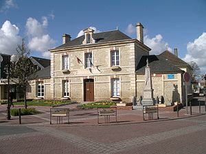
 Démouville Town Hall |
||
Démouville is a French municipality with 3189 inhabitants (as of January 1 2017) in the department of Calvados in the region of Normandy ; it belongs to the arrondissement of Caen and the canton of Troarn .
geography
Démouville is a banlieue about seven kilometers away in the east of Caen . Démouville is surrounded by the neighboring communities Cuverville in the north, Saline with Sannerville in the east, Cagny in the south and Giberville in the west.
The A13 autoroute runs through the municipality .
history
In 1066 the place is mentioned as Demolt villa and as early as 1126 as Demouvilla .
Population development
| year | 1962 | 1968 | 1975 | 1982 | 1990 | 1999 | 2006 | 2011 |
|---|---|---|---|---|---|---|---|---|
| Residents | 788 | 1,045 | 1,373 | 2.165 | 2,495 | 3,052 | 3.143 | 3,313 |
Source: INSEE
Attractions
- Notre-Dame church from the 13th / 14th centuries Century, Monument historique since 1932
Partner communities
Since 1987 there has been a partnership with the community of Wesendorf in Lower Saxony .
Individual evidence
- ^ Démouville on the Insee website
- ↑ Entry about the partner communities on the homepage of the integrated community Wesendorf.Retrieved on April 17, 2019, 8:02 pm
Web links
Commons : Démouville - collection of images, videos and audio files

