
District of Büren
| coat of arms | Germany map |
|---|---|

|

Coordinates: 51 ° 33 ' N , 8 ° 34' E |
| Basic data (as of 1974) | |
| Existing period: | 1816-1974 |
| State : | North Rhine-Westphalia |
| Administrative region : | Detmold |
| Regional association : | Westphalia-Lippe |
| Administrative headquarters : | Büren |
| Area : | 767.08 km 2 |
| Residents: | 64,000 (Dec. 31, 1973) |
| Population density : | 83 inhabitants per km 2 |
| License plate : | OFFICE |
| Circle key : | 05 7 32 |
| Circle structure: | 54 parishes |
| Address of the district administration: |
Lindenstrasse 12 4793 Büren |
| District Administrator : | Felix Klingenthal ( CDU ) |
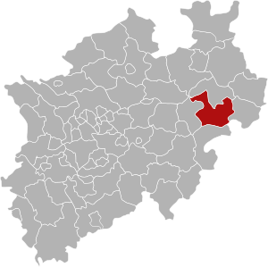
| Location of the Büren district in North Rhine-Westphalia | |
  |
|

The county Buren (1816-1969: County Buren ) was from 1816 to 1974 existing circle . The district was initially part of the administrative district of Minden in the Prussian province of Westphalia , from 1946/47 part of the North Rhine-Westphalian administrative district of Detmold . The administrative seat was Büren . The district went up in 1975 as part of the North Rhine-Westphalian regional reform together with the old Paderborn district in the newly founded Paderborn district .
geography
location
Most of the former district area is covered by the Paderborn plateau with its southern partial landscapes. The Egge Mountains delimit the district to the east. In the southeast it extends into the Diemelsenke . In the south, the district also had a share in the Sauerland . Here is the highest point of the district "Am Totenkopf" near Bleireinigung at 498 m above sea level. NN . In the northwest, the district has a share of the lip lowlands and the eastern Hellweg area . The area of the former district is now also referred to as Bürener Land .
Neighboring areas
In 1973, the Büren district bordered clockwise in the north, starting with the Paderborn and Warburg districts (both in North Rhine-Westphalia), the Waldeck district (in Hesse ) and the Brilon and Lippstadt districts (both in North Rhine-Westphalia).
history
The area of the Büren district originally belonged to the Principality of Paderborn . From 1807 to 1813 the later district area was part of the Kingdom of Westphalia and received an administrative structure based on the French model. It now belonged to the Paderborn district in the Fulda department and was subdivided into the five cantons of Atteln, Büren, Lichtenau, Ringboke (= Boke), Salzkotten and Wünnenberg.
After the end of the French era , the district first belonged to the Prussian civil government between the Weser and the Rhine and from 1815 to the new Prussian province of Westphalia . The administrative district of Minden , founded within the province of Westphalia , was divided into twelve districts on November 1, 1816, including the Büren district. The cantons founded in 1807 initially continued to exist as an administrative district, sometimes also referred to as the mayor's office .
In 1832 Oberntudorf and Niederntudorf were reclassified from the Paderborn district to the Büren district. As part of the introduction of the rural community order for the province of Westphalia, the district was divided into the six offices of Atteln , Boke , Büren , Lichtenau , Salzkotten and Wünnenberg in 1844. The city of Salzkotten remained vacant.
The two offices of Boke and Salzkotten were administered by a common bailiff in personal union since 1859. In 1861 the new community of Mantinghausen was formed from a part of Rebbeke . The city of Büren left the office of Büren in 1895, which was later called the office of Büren-Land .
In 1938 the offices of Salzkotten and Boke were finally merged to form the office of Salzkotten-Boke . At the same time, the city of Salzkotten lost its freedom of office and was incorporated into this office. In 1939, the community was Keddinghausen after Hegendorf incorporated. On August 10, 1952, the municipality of Dalheim-Blankenrode was divided into the three municipalities of Blankenrode , Dalheim and Elisenhof . In 1969 the city and the office of Büren set up an administrative association in anticipation of the local government reform.
On October 1, 1969, the district became the Büren district.
On January 1, 1975, almost the entire area of the district was merged with the old Paderborn district by the Sauerland / Paderborn law . Essentho , Meerhof , Oesdorf and Westheim came to Marsberg and thus to the Hochsauerlandkreis ; the three Lippe communities Garfeln , Hörste and Rebbeke were incorporated into the city of Lippstadt by Section 45 of the Münster / Hamm Act and thus became part of the Soest district . Etteln came to Borchen and the three Lippe communities Anreppen , Bentfeld and Boke to Delbrück . The remaining municipalities were merged into the four cities of Büren , Lichtenau , Salzkotten and Wünnenberg .
The legal successor of the Büren district is the Paderborn district . When the two districts merged, it was agreed that the district culture office as well as the district archive of the new district and some branch offices would be located in Büren. While today almost all traces of the Büren district are blurred at the administrative level (the district culture office and the Paderborn district archive are located in Büren and the branch of the Paderborn district road traffic office was closed a few years ago), the Büren district exists elsewhere Still today: The district rifle festival, which takes place every year in September, is only attended by those places that formed the Büren district up to 1975, as well as the neighboring communities of the old district by invitation.
Population development

| year | population |
|---|---|
| 1818 | 29,130 |
| 1831 | 32,754 |
| 1837 | 34,476 |
| 1843 | 37,687 |
| 1849 | 38,564 |
| 1852 | 38,669 |
| 1867 | 36,443 |
| 1871 | 35,441 |
| 1885 | 35,735 |
| 1905 | 37.091 |
| 1925 | 40,670 |
| 1933 | 43,242 |
| 1939 | 43,398 |
| 1946 | 63,841 |
| 1950 | 62,247 |
| 1957 | 57,068 |
| 1961 | 57,677 |
| 1965 | 59,794 |
| 1970 | 61,988 |
| 1973 | 64,000 |
politics
Results of the district elections from 1946
The list only shows parties and constituencies that received at least two percent of the votes in the respective election.
Share of votes of the parties in percent
| year | CDU | SPD | DZP | BHE | FDP |
|---|---|---|---|---|---|
| 1946 | 67.5 | 12.7 | 18.3 | ||
| 1948 | 42.7 | 15.1 | 28.8 | 11.6 | |
| 1952 | 34.9 | 12.8 | 34.7 | 11.1 | 5.7 |
| 1956 | 50.2 | 15.6 | 21.8 | 9.7 | 2.7 |
| 1961 | 67.4 | 14.2 | 10.1 | 8.3 | |
| 1964 | 67.2 | 19.4 | 13.4 | ||
| 1969 | 64.2 | 23.5 | 12.3 |
District administrators
- 1816–1843: Joseph von Hartmann (* 1780 in Paderborn, † 1859 in Heiligenstadt)
- 1843–1848: Joseph Theodor zu Stolberg-Stolberg (1804–1859 in Roumillies near Tournay)
- 1848–1870: Reinhard Franz von und zu Brenken (* 1818 zu Brenken; † 1870)
- 1871–1875: Clemens Friedrich Droste zu Hülshoff (* 1837 at Hülshoff Castle , † 1919 at Haus Stapel )
- 1875–1895: Börries von Oeynhausen (* 1836 in Braunschweig, † 1896 in Kassel)
- 1895–1912: Karl von Savigny (* 1855 in Karlsruhe; † 1928 on Gut Trages near Gelnhausen)
- 1913–1921: Adolf Winkelmann
- 1921–1925: Alois Vogels , center
- 1925–1933: Viktor von Solemacher-Antweiler
- 1934–1945: Ferdinand Eickel , NSDAP
- 1946–1949: Josef Parensen, CDU (* 1878 in Nieheim)
- 1949–1954: Franz Böhner , center
- 1954–1967: Heinrich Wilper , CDU
- 1967–1969: Meinolf Stieren , CDU
- 1969–1974: Felix Klingenthal , CDU
Upper District Directors
- 1946–1955: Josef Ebbers († 1955)
- 1955–1963: Werner Greve
- 1963–1974: Hermann Kaup († 2013)
coat of arms
In silver, a red diamond chevron in seven parts under a red shield head with a continuous golden cross.
Municipalities of the Büren district
According to offices (December 31, 1973)
Vacant
- Büren (Westphalia) , city: 6.243 E, 26 km², 230 m above sea level. NHN
- Atteln : 949 E, 15 km², 196 m above sea level. NHN
- Blankenrode : 98 E, 10 km², 369 m above sea level. NHN
- Dalheim : 126 E, 10 km², 274 m above sea level. NHN
- Elisenhof : 111 E, 8 km², 332 m above sea level. NHN
- Etteln : 1413 E, 23 km², 162 m above sea level. NHN
- Haaren : 1825 E, 33 km², 361 m above sea level NHN
- Helmern : 813 E, 13 km², 362 m above sea level. NHN
- Henglarn : 594 E, 11 km², 179 m above sea level. NHN
- Husen : 853 E, 14 km², 213 m above sea level. NHN
- Ahden : 844 E, 10 km², 179 m above sea level. NHN
- Barkhausen : 154 E, 6 km², 331 m above sea level. NHN
- Brenken : 1948 E, 27 km², 201 m above sea level. NHN
- Eickhoff : 111 E, 8 km², 332 m above sea level. NHN
- Harth : 997 E, 18 km², 349 m above sea level. NHN
- Hegensdorf : 858 E, 15 km², 265 m above sea level. NHN
- Siddinghausen : 925 E, 10 km², 303 m above sea level. NHN
- Steinhausen : 2221 E, 14 km², 240 m above sea level. NHN
- Weiberg : 617 E, 5 km², 350 m above sea level. NHN
- Wines : 522 E, 7 km², 228 m above sea level. NHN
- Wewelsburg : 2000 E, 26 km², 219 m above sea level. NHN
- Woodlice : 377 E, 11 km², 328 m above sea level NHN
- Ebbinghausen : 150 E, 4 km², 207 m above sea level. NHN
- Foundation stone home : 378 E, 10 km², 240 m above sea level. NHN
- Hakenberg : 241 E, 8 km², 363 m above sea level. NHN
- Herbram : 877 E, 17 km², 277 m above sea level. NHN
- Holtheim : 825 E, 16 km², 336 m above sea level. NHN
- Iggenhausen : 161 E, 5 km², 270 m above sea level. NHN
- Kleinenberg , city: 1227 E, 24 km², 335 m above sea level. NHN
- Lichtenau , city: 1581 E, 33 km², 305 m above sea level. NHN
- Stepping up : 899 E, 10 km², 90 m above sea level. NHN
- Bentfeld : 871 E, 8 km², 94 m above sea level. NHN
- Boke : 1817 E, 16 km², 90 m above sea level. NHN
- Garfeln : 403 E, 4 km², 82 m above sea level. NHN
- Hörste near Lippstadt: 1215 E, 7 km², 82 m above sea level. NHN
- Mantinghausen : 627 E, 6 km², 83 m above sea level. NHN
- Niederntudorf : 1733 E, 15 km², 162 m above sea level. NHN
- Oberntudorf : 880 E, 6 km², 180 m above sea level. NHN
- Rebbeke : 608 E, 12 km², 82 m above sea level. NHN
- Salzkotten , city: 5949 E, 24 km², 97 m above sea level. NHN
- Scharmede : 1850 E, 9 km², 106 m above sea level. NHN
- Threshold : 563 E, 8 km², 85 m above sea level. NHN
- Thüle : 1390 E, 15 km², 97 m above sea level. NHN
- Upsprunge : 974 E, 8 km², 105 m above sea level. NHN
- Verlar : 742 E, 4 km², 84 m above sea level NHN
- Verne : 2250 E, 16 km², 98 m above sea level. NHN
- Lead washing : 802 E, 9 km², 453 m above sea level NHN
- Essentho : 1132 E, 12 km², 420 m above sea level. NHN
- Fürstenberg : 1948 E, 59 km², 345 m above sea level. NHN
- Leiberg : 1206 E, 16 km², 324 m above sea level. NHN
- Meerhof : 1095 E, 19 km², 410 m above sea level NHN
- Oesdorf : 717 E, 9 km², 318 m above sea level. NHN
- Westheim : 1868 E, 12 km², 228 m above sea level. NHN
- Wünnenberg , city: 2209 E, 29 km², 334 m above sea level. NHN
License Plate
On July 1, 1956, when the vehicle license plates were introduced, the BÜR was assigned to the then district . It was issued until December 31, 1974. It has been available in the Paderborn district since November 24, 2014 due to the license plate liberalization .
literature
- Gerhard Henkel: History and geography of the Büren district . Ed .: District administration Büren. Paderborn 1974, ISBN 3-506-73840-2 .
- Inventories of the non-governmental archives of the Büren district . Aschendorff, Münster i. W. 1915 ( digitized edition of the University and State Library Düsseldorf ).
Web links
Individual evidence
- ^ Regional Association Westphalia-Lippe (ed.); Project Westphalian History: "Royal Decree, whereby the division of the kingdom into eight departments is ordered", page 107
- ^ Westphalia Lexicon 1832-1835 . In: Landschaftsverband Westfalen-Lippe (Ed.): Reprints for the Westphalian archive maintenance . tape 3 . Münster 1978, p. 158 (reprint of the original from 1834).
- ^ Official Journal of the Minden Government 1831: Change in the regional division of Westphalia
- ↑ Landgemeinde -ordnung for the Province of Westphalia from October 31, 1841 (PDF; 1.6 MB)
- ^ Official Journal of the Minden Government 1844. Retrieved February 2, 2014 .
- ^ Official Journal of the Minden Government 1859
- ^ Official Journal of the Minden Government 1862
- ^ A b Wolfgang Leesch: Administration in Westphalia 1815–1945 . In: Publications of the Historical Commission for Westphalia . tape 38 . Aschendorff, Münster 1992, ISBN 3-402-06845-1 .
- ↑ Stephanie Reekers: The regional development of the districts and communities of Westphalia 1817-1967 . Aschendorff, Münster Westfalen 1977, ISBN 3-402-05875-8 , p. 225 .
- ↑ Announcement of the new version of the district regulations for the state of North Rhine-Westphalia from August 11, 1969 in the Law and Ordinance Gazette for the state of North Rhine-Westphalia, year 1969, No. 2021, p. 670 ff.
- ^ Federal Statistical Office (ed.): Historical municipality directory for the Federal Republic of Germany. Name, border and key number changes in municipalities, counties and administrative districts from May 27, 1970 to December 31, 1982 . W. Kohlhammer, Stuttgart / Mainz 1983, ISBN 3-17-003263-1 , p. 320 f .
- ↑ Statistical Yearbook for the Federal Republic of Germany 1975
- ↑ Source: respective issue of the State Statistical Office (LDS NRW), Mauerstr. 51, Düsseldorf, with the election results at the district level.
- ↑ Hermann Kaup died. Neue Westfälische , April 2, 2013, accessed April 15, 2013 .
- ^ Paderborn district - Paderborn district mourns Hermann Kaup. (No longer available online.) Paderborn district , April 2, 2013, formerly in the original ; Retrieved April 15, 2013 (press release). ( Page no longer available , search in web archives ) Info: The link was automatically marked as defective. Please check the link according to the instructions and then remove this notice.

Districts: Ahaus | Altena | Arnsberg | Beckum | Bielefeld | Bilstein | Bochum | Bark | Brakel | Brilon | Frets | Büren | Coesfeld | Dortmund | Ennepe-Ruhr district | Eslohe | Gelsenkirchen | Hagen | Halle (Westphalia) | Hamm | Hattingen | Herford | Hörde | Höxter | Iserlohn | Lippstadt | Lübbecke | Lüdinghausen | Medebach | Meschede | Minden | Munster | Olpe | Paderborn | Rahden | Recklinghausen | Schwelm | Victories | Soest | Steinfurt | Tecklenburg | Unna | Warburg | Warendorf | Wiedenbrück | Wittgenstein
City districts: Bielefeld | Bocholt | Bochum | Bottrop | Buer | Castrop-Rauxel | Dortmund | Gelsenkirchen | Gelsenkirchen-Buer | Gladbeck | Hagen | Hamm | Herford | Herne | Hörde | Iserlohn | Lüdenscheid | Lünen | Minden | Munster | Osterfeld | Recklinghausen | Victories | Wanne-Eickel | Wattenscheid | Witten

Before the founding of North Rhine-Westphalia in what is now North Rhine-Westphalia, the (rural) districts: Bilstein | Blankenheim | Bochum | Brakel | Frets | Dortmund | Duisburg | Düsseldorf | Elberfeld | Eslohe | Food | Geilenkirchen | Gelsenkirchen | Gemünd | Gimborn | Gladbach | Grevenbroich-Neuss | Gummersbach | Hagen | Hamm | Hattingen | Heinsberg (1816-1932) | Homburg | Hörde | Kempen | Krefeld | Lechenich | Lennep | Medebach | Mettmann | Mülheim am Rhein | Mülheim an der Ruhr | Neuss | Opladen | Rahden | Rheinbach | Rheinberg | Ruhrort | Schwelm | Solingen | Solingen-Lennep | Uckerath | Waldbröl | Wipperfürth
Former North Rhine-Westphalian (rural) districts: Aachen (1816–1971) | Aachen (1972–2009) | Ahaus | Altena | Arnsberg | Beckum | Bergheim (Erft) | Bielefeld | Bonn | Borken (1816–1974) | Brilon | Büren | Coesfeld (1816–1974) | Detmold | Dinslaken | Düren (1816–1971) | Düsseldorf-Mettmann | Erkelenz | Geilenkirchen-Heinsberg | Geldern | Grevenbroich | Halle (Westphalia) | Höxter (1816–1974) | Iserlohn | Jülich | Kempen-Krefeld | Cologne | Lemgo | Lippstadt | Lübbecke | Lüdenscheid | Lüdinghausen | Meschede | Minden | Moers | Monschau | Munster | Paderborn (1816–1974) | Rees | Rhein-Wupper-Kreis | Schleiden | Selfkantkreis Geilenkirchen-Heinsberg | Victories | Siegkreis | Soest (1817–1974) | Steinfurt (1816–1974) | Tecklenburg | Unna (1930–1974) | Warburg | Warendorf (1816–1974) | Wiedenbrück | Wittgenstein