
Chusclan
| Chusclan | ||
|---|---|---|
.svg)
|
|
|
| region | Occitania | |
| Department | Gard | |
| Arrondissement | Nîmes | |
| Canton | Bagnols-sur-Cèze | |
| Community association | Gard Rhodania | |
| Coordinates | 44 ° 9 ' N , 4 ° 41' E | |
| height | 28-268 m | |
| surface | 13.23 km 2 | |
| Residents | 967 (January 1, 2017) | |
| Population density | 73 inhabitants / km 2 | |
| Post Code | 30200 | |
| INSEE code | 30081 | |
| Website | http://www.chusclan.fr/ | |
 Town hall (Mairie) of Chusclan |
||

Chusclan is a French commune with 967 inhabitants (as of January 1, 2017) in the Gard department of the Occitanie region . The municipality belongs to the Arrondissement of Nîmes and the canton of Bagnols-sur-Cèze .
geography
Chusclan is about ten kilometers west of Orange . The Rhône limits the municipality to the east. The Marcoule nuclear power plant is located between the Chusclan and the Rhône . Chusclan is surrounded by the neighboring communities of Vénéjan in the north, Saint-Étienne-des-Sorts in the north and northeast, Piolenc in the east, Caderousse in the southeast, Codolet in the south and southeast, Orsan in the south and southwest and Bagnols-sur-Cèze in the west.
Wines from the Côtes du Rhône appellation are produced here.
Population development
| year | 1962 | 1968 | 1975 | 1982 | 1990 | 1999 | 2006 | 2013 |
| Residents | 576 | 616 | 668 | 809 | 941 | 908 | 959 | 994 |
| Source: Cassini and INSEE | ||||||||
Attractions
- Saint-Julien-et-Saint-Emétery church, former priory, church from the 10th century
- Sainte-Madeleine Chapel, Romanesque church building from the 11th century
- Gicon Castle
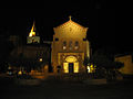
Saint-Julien-et-Saint-Emétery church

Convention
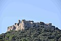
Gicon Castle


Personalities
- Alexis-Basile-Alexandre Menjaud (1791–1861), Bishop of Nancy and Archbishop of Bourges
Web links