
Vestric-et-Candiac
| Vestric-et-Candiac | ||
|---|---|---|
.svg)
|
|
|
| region | Occitania | |
| Department | Gard | |
| Arrondissement | Nîmes | |
| Canton | Vauvert | |
| Community association | Rhôny Vistre Vidourle | |
| Coordinates | 43 ° 44 ′ N , 4 ° 16 ′ E | |
| height | 12-83 m | |
| surface | 10.92 km 2 | |
| Residents | 1,406 (January 1, 2017) | |
| Population density | 129 inhabitants / km 2 | |
| Post Code | 30600 | |
| INSEE code | 30347 | |
 Mairie Vestric-en-Candiac |
||

Vestric-et-Candiac is a French commune with 1,406 inhabitants (as of January 1, 2017) in the Gard department in the Occitanie region . Vestric-et-Candiac belongs to the Arrondissement of Nîmes and the Canton of Vauvert (until 2015: Canton of Rhôny-Vidourle ). The inhabitants are called Vestriçois .
geography
Vestric-et-Candiac is twelve kilometers southwest of Nîmes in the so-called Little Camargue . The Vistre flows through the municipality . Vestric-et-Candiac is surrounded by the neighboring communities of Uchaud in the north and northeast, Beauvoisin in the east and southeast, Vauvert in the south, Le Cailar in the southwest, Vergèze in the west and Boissières in the northwest.
The A9 car route runs through the municipality .
Population development
| year | 1962 | 1968 | 1975 | 1982 | 1990 | 1999 | 2006 | 2017 |
|---|---|---|---|---|---|---|---|---|
| Residents | 313 | 436 | 503 | 654 | 1001 | 1324 | 1328 | 1406 |
| Sources: Cassini and INSEE | ||||||||
Attractions
- Notre-Dame Catholic Church
- Protestant church
- Candiac Castle
- Montcalm Castle, monument historique since 1944
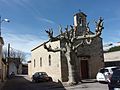
Notre-Dame church
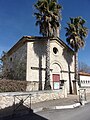
Protestant church

Water tower


