Pougnadoresse
| Pougnadoresse | ||
|---|---|---|

|
|
|
| region | Occitania | |
| Department | Gard | |
| Arrondissement | Nîmes | |
| Canton | Uzes | |
| Community association | Pays d'Uzès | |
| Coordinates | 44 ° 6 ′ N , 4 ° 30 ′ E | |
| height | 120-241 m | |
| surface | 7.65 km 2 | |
| Residents | 246 (January 1, 2017) | |
| Population density | 32 inhabitants / km 2 | |
| Post Code | 30330 | |
| INSEE code | 30205 | |
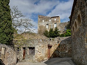
 Section from the townscape |
||
Pougnadoresse ( Occitan Pinhadorèissa ) is a French commune with 246 inhabitants (as of January 1, 2017) in the Gard department in the Occitanie region .
geography
Pougnadoresse is 31 kilometers north-east of Nîmes and just as far north-west of Avignon . The next larger towns are the cities of Uzès in the southwest and Bagnols-sur-Cèze in the northeast, each around 12 kilometers away . The Rhone Valley is to the east of the village , while the Cevennes Mountains begin in the west . The municipality is traversed by the Tave and the Valette and Veyre streams . The municipality is an official member of the Côtes du Rhône wine-growing region and is shaped accordingly by wine cultivation. In addition to the core town, the community includes the hamlet of Mas Carrière . The latter belongs to part of the area covered by loess soil , while another part is characterized by mountain ranges and rocky subsoil.
The neighboring communities of Pougnadoresse are Cavillargues in the north, Le Pin in the east, La Capelle-et-Masmolène and Vallabrix in the south and La Bastide-d'Engras in the west.
Infrastructure
The only connection to the road network for Pougnadoresse is via local roads to the neighboring towns, although in Cavillargues, a few kilometers to the north, there is a connection to a regional transport axis to Bagnols-sur-Cèze and the Rhône Valley, which connects to a road to Alès in a westerly direction .
Culture and history
Place name
The first mention of the place with the associated castle took place in 1156 under the name Castrum de Pugnaduritia . At that time it was owned by the bishops of Uzès . A possible explanation for the origin of the name is the Latin word pugnator , which means warrior, in combination with the suffix icia . The earlier common name variation Pignadouresso , however, suggests a different meaning. It could be a derivation of the Occitan word penna for rocks, which could be due to the partly rocky environment.
Buildings
The feudal castle of Pougnadoresse, the existence of which has been documented since 1156, has particularly stable outer walls up to two meters thick. Together with the village it belonged first to the bishops of Uzès, then partly to the Lord of Sernhac and partly to a local nobleman, before it passed into the possession of the Le Chantre family in 1550 and remained there for many years. In 1780 the de Sorbier family took over the rule, at least they were able to keep the castle beyond the French Revolution and are still the owners today.
Until 1678, the Catholic Church of Saint Jean d'Orgerolles , which is still preserved today, was the only religious building in the community. Because it was located on a range of hills between Pougnadoresse and La Bastide-d'Engras and was even closer to the neighboring town, he donated Archbishop built a new church in the town center in 1678. It was expanded in 1688 and replaced by a successor church in 1861. Seven years after the construction, the interior was expanded, seating was added and a second sacristy was created. In 1873 it was also given a bell tower and a second was added three years later.
The first school in the village was a religious school, which was located in 1885 on the ground floor of a building on the first floor of which the Mairie was housed as the seat of the municipal administration. In 1905 the Mairie took over the lower floor and apartments for the teachers were created above. The school continued until it was closed in 1984 due to a lack of student numbers; Since then, the children have attended classes in the neighboring village of Cavillargues.
There were originally four mills on the banks of the River Tave, two of which have largely been preserved and the other two remain in a ruinous state. The brook Veyre, which has dried up for much of the year, is spanned by a bridge, the existence of which has been proven since 1521 and which was reconstructed in 1994 by a cultural association based on the historical model.
Population development
| year | 1962 | 1968 | 1975 | 1982 | 1990 | 1999 | 2010 | 2017 |
|---|---|---|---|---|---|---|---|---|
| Residents | 127 | 134 | 126 | 123 | 131 | 165 | 216 | 246 |
In 1793 the community was inhabited by 253 people and it then experienced a significant increase to 384 residents in 1861. This was followed by a sharp decline, so that in 1906 with 255 registered residents the old level was reached again. The number continued to decline rapidly, bottoming out at 123 in 1982, followed by a period of strong population recovery.
Web links
Individual evidence
- ↑ Mairie de Pougnadoresse , annuaire-mairie.fr
- ↑ a b Découvrir Pougnadoresse , pougna.pagesperso-orange.fr
- ↑ L'histoire de Pougnadoresse , pougna.pagesperso-orange.fr
- ↑ Pougnadoresse - Notice Communale , cassini.ehess.fr
