
Saint-André-d'Olérargues
|
Saint-André-d'Olérargues Sent Andrieu d'Olerargues |
||
|---|---|---|
.svg)
|
|
|
| region | Occitania | |
| Department | Gard | |
| Arrondissement | Nîmes | |
| Canton | Pont-Saint-Esprit | |
| Community association | Gard Rhodania | |
| Coordinates | 44 ° 8 ′ N , 4 ° 21 ′ E | |
| height | 86-263 m | |
| surface | 9.75 km 2 | |
| Residents | 429 (January 1, 2017) | |
| Population density | 44 inhabitants / km 2 | |
| Post Code | 30580 | |
| INSEE code | 30232 | |
| Website | http://www.mairie-saintandredolerargues.fr/ | |
 Aerial view of Saint-André-d'Olérargues |
||

Saint-André-d'Olérargues ( Occitan : Sent Andrieu d'Olerargues ) is a French commune with 845 inhabitants (as of January 1, 2017) in the Gard department in the Occitanie region . It belongs to the arrondissement of Nîmes and the canton of Pont-Saint-Esprit (until 2015: canton of Lussan ). The inhabitants are called Olérargais .
geography
Saint-André-d'Olérargues is located about 38 kilometers north-northeast of Nîmes and about 26 kilometers west-northwest of Orange . The neighboring municipalities of Saint-André-d'Olérargues are Verfeuil in the north and west, La Roque-sur-Cèze in the northeast, Sabran in the east and Saint-Marcel-de-Careiret in the south.
Population development
| year | 1962 | 1968 | 1975 | 1982 | 1990 | 1999 | 2006 | 2017 |
|---|---|---|---|---|---|---|---|---|
| Residents | 144 | 153 | 145 | 192 | 268 | 289 | 393 | 429 |
| Source: Cassini and INSEE | ||||||||
Attractions
- Romanesque church Saint-André from the 12th / 13th centuries century
- Castle from the 13th / 14th centuries century

Saint-André church
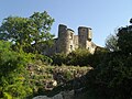
Castle


Web links
Commons : Saint-André-d'Olérargues - Collection of images, videos and audio files