Saint-Laurent-la-Vernède
| Saint-Laurent-la-Vernède | ||
|---|---|---|

|
|
|
| region | Occitania | |
| Department | Gard | |
| Arrondissement | Nîmes | |
| Canton | Uzes | |
| Community association | Pays d'Uzès | |
| Coordinates | 44 ° 6 ′ N , 4 ° 28 ′ E | |
| height | 177-302 m | |
| surface | 11.8 km 2 | |
| Residents | 681 (January 1, 2017) | |
| Population density | 58 inhabitants / km 2 | |
| Post Code | 30330 | |
| INSEE code | 30279 | |
| Website | http://www.saint-laurent-la-vernede.fr/ | |
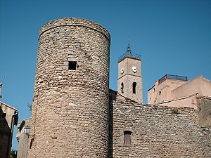
 Fortress and bell tower |
||
Saint-Laurent-la-Vernède is a French commune with 681 inhabitants (as of January 1, 2017) in the Gard department in the Occitanie region .
geography
Saint-Laurent-la-Vernède is 35 kilometers north of Nîmes and 40 kilometers northwest of Avignon . The next larger towns are Uzès, twelve kilometers to the south, and Bagnols-sur-Cèze , about 18 kilometers to the northwest. The Rhone Valley lies to the east , while the Cevennes Mountains begin in the west . The municipality is traversed by the Tave and the Brives brook. It is heavily influenced by agricultural use.
The neighboring municipalities of Saint-Laurent-la-Vernède are Saint-Marcel-de-Careiret in the north, Cavillargues and La Bastide-d'Engras in the east, Saint-Quentin-la-Poterie in the south and Fontarèches in the west.
Infrastructure
The village is connected to the neighboring towns via local roads. The D6 road north of the town center connects to Bagnols-sur-Cèze to the east and Alès to the west .
Culture and history
history
The place was first mentioned in 1122 under the name villa Sancti-Laurentii de Verneda . It is also known from the Middle Ages that the village was owned by the Lords of Uzès in the early 13th century. In June 1445, the construction of a fortification began, which was financed by several wealthy citizens of Saint-Laurent. For this purpose, protective walls were built, within which those same citizens settled. This protected them from conflicts such as the Huguenot Wars , which affected the region in the 16th century. The protected area was given the nickname quartier neuf (new quarter) and contained important centers of public life with the church and the cemetery. Economically, the village in the late Middle Ages was mainly characterized by an outlying glassworks . Due to the immense consumption of materials, production was stopped in 1496.
As in other places in the region, Protestantism was at times widespread in Saint-Laurent-la-Vernède, which is why the Catholic Church was converted into a Huguenot house of prayer in the 16th and 17th centuries. In 1745 Joseph de Thomas acquired the right to rule over the place and a year later began a legal dispute over the ownership rights to the timber harvest . The process dragged on for 42 years and in 1788 led to the judgment that the gentleman should be entitled to a quarter of the harvest.
Buildings and sights
Since its construction in the 15th century, the local fortress has withstood all wars, conflicts and the French Revolution , which is why it has survived to this day. The village church in its current form was built in the middle of the 19th century when the previously existing church building was expanded. It was extended by a length of six meters and thus extends to the north facade of the fortress. The associated bell tower was built a few decades earlier and contains a bell that was cast in Marseille in 1818 .
In the place there is a lavoir , whose original purpose was to irrigate the communal vegetable gardens. These are now supplied by a modern pump system. In memory of the fallen of the First World War, there is a war memorial in Saint-Laurent-la-Vernède consisting of an iron cross with a figure of Christ and a marble slab with the names of the dead soldiers. The public fountain in the center of the village probably dates from the 19th century. There are several wayside crosses spread across the municipality .
Population development
| year | 1962 | 1968 | 1975 | 1982 | 1990 | 1999 | 2011 | 2017 |
|---|---|---|---|---|---|---|---|---|
| Residents | 241 | 238 | 295 | 380 | 535 | 592 | 722 | 681 |
In 1793 the community was inhabited by 361 people and it then experienced a significant increase to 498 inhabitants in 1881. This was followed by a sharp decline, so that the number fell below the 300 mark in the 1930s. A historic low was reached in 1968 with 238 registered residents. After that, especially in the 1980s, there was strong population growth.
Web links
Individual evidence
- ↑ Fiche d'identité - plan , saint-laurent-la-vernede.fr
- ↑ Mairie de Saint-Laurent-la-Vernède , annuaire-mairie.fr
- ↑ a b c histoire du village , saint-laurent-la-vernede.fr
- ↑ Saint-Laurent-la-Vernède - Notice Communale , cassini.ehess.fr
