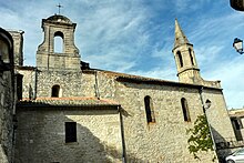
Saint-Maximin (Gard)
|
Saint-Maximin Sent Corn Semin |
||
|---|---|---|

|
|
|
| region | Occitania | |
| Department | Gard | |
| Arrondissement | Nîmes | |
| Canton | Uzes | |
| Community association | Pays d'Uzès | |
| Coordinates | 44 ° 0 ′ N , 4 ° 27 ′ E | |
| height | 40-202 m | |
| surface | 9.9 km 2 | |
| Residents | 746 (January 1, 2017) | |
| Population density | 75 inhabitants / km 2 | |
| Post Code | 30700 | |
| INSEE code | 30286 | |
Saint-Maximin ( Occitan : Sent Maissemin ) is a French commune with 746 inhabitants (as of January 1, 2017) in the Gard department in the Occitanie region . The municipality belongs to the Arrondissement of Nîmes and the Canton of Uzès .
geography
Saint-Maximin is about 33 kilometers west-southwest of Orange . The municipality is crossed by the Alzon River. Saint-Maximin is surrounded by the neighboring communities of Saint-Siffret in the north and northeast, Argilliers in the east, Collias in the south and southeast, Sanilhac-Sagriès in the south and southwest and Uzès in the west.
Population development
| year | 1962 | 1968 | 1975 | 1982 | 1990 | 1999 | 2006 | 2017 |
|---|---|---|---|---|---|---|---|---|
| Residents | 243 | 255 | 278 | 393 | 628 | 630 | 609 | 746 |
| Sources: Cassini and INSEE | ||||||||
Culture and sights
- Saint-Maximin Church
- Racine Castle, residence of Jean Racine 1661/62
Web links
Commons : Saint-Maximin - Collection of images, videos and audio files

