
Sainte-Anastasie (Gard)
|
Sainte-Anastasie Senta Anastasiá |
||
|---|---|---|
.svg)
|
|
|
| region | Occitania | |
| Department | Gard | |
| Arrondissement | Nîmes | |
| Canton | Uzes | |
| Community association | Nîmes metropolis | |
| Coordinates | 43 ° 56 ' N , 4 ° 19' E | |
| height | 33-207 m | |
| surface | 43.64 km 2 | |
| Residents | 1,686 (January 1, 2017) | |
| Population density | 39 inhabitants / km 2 | |
| Post Code | 30190 | |
| INSEE code | 30228 | |

Sainte-Anastasie ( Occitan : Senta Anastasiá ) is a southern French municipality with 1686 inhabitants (as of January 1, 2017) in the Gard department in the Occitania region . The municipality belongs to the arrondissement of Nîmes and the canton of Uzès (until 2015: canton of Saint-Chaptes ). The inhabitants are called Anastasia .
The four localities Aubarne , Campagnac , Russan and Vic belong to the municipality.
location
Sainte-Anastasie is located about eleven kilometers north-northwest of the city center of Nîmes on the Gardon , into which the Bourdic flows here. Sainte-Anastasie is surrounded by the neighboring communities Garrigues-Sainte-Eulalie and Bourdic in the north, Blauzac in the northeast, Sanilhac-Sagriès in the east and northeast, Poulx in the east and southeast, Nîmes in the south, Dions in the west and Saint-Chaptes in the northwest.
Population development
| year | 1962 | 1968 | 1975 | 1982 | 1990 | 1999 | 2006 | 2017 |
| Residents | 706 | 708 | 732 | 870 | 1028 | 1270 | 1557 | 1686 |
| Sources: Cassini and INSEE | ||||||||
Attractions
- The Gorges du Gardon as a nature reserve ( canyon )
- Saint-Nicolas de Campagnac bridge, Monument historique
- Saint-Nicolas Priory
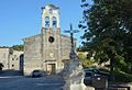
- Churches in Aubarne, Russan and Vic
- Caves with paintings of the Franco-Cantabrian cave art

Church in Aubarne
Church in Russan

Bridge and Priory Saint-Nicolas in Campagnac

Saint-Nicolas bridge

Church in Vic


Web links
notes