Goudargues
| Goudargues | ||
|---|---|---|

|
|
|
| region | Occitania | |
| Department | Gard | |
| Arrondissement | Nîmes | |
| Canton | Pont-Saint-Esprit | |
| Community association | Gard Rhodania | |
| Coordinates | 44 ° 13 ' N , 4 ° 28' E | |
| height | 70-332 m | |
| surface | 30.27 km 2 | |
| Residents | 1,100 (January 1, 2017) | |
| Population density | 36 inhabitants / km 2 | |
| Post Code | 30630 | |
| INSEE code | 30131 | |
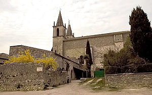
 Notre-Dame and Saint-Michel church |
||
Goudargues is a French commune with 1100 inhabitants (as of January 1, 2017) in the Gard department and the Occitania region . It is located at the southern end of the Gorges de la Cèze ; the municipality is largely covered by Mediterranean forest.
history
Several dolmens in the hills around the place indicate an early settlement of the area. The current place probably goes back to a settlement from the 8th century. After the victory over the Sarrazenen , a nephew of Charlemagne had a small monastery built. A second, larger monastery and a Romanesque chapel were probably built towards the end of Charles' reign. Probably in the 12th century a barrel vaulted hall was built , which was the refectory and which is used culturally today.
| 1962 | 1968 | 1975 | 1982 | 1990 | 1999 | 2008 | 2017 |
|---|---|---|---|---|---|---|---|
| 637 | 645 | 612 | 680 | 788 | 945 | 1021 | 1100 |
Personalities
- Jean Carmet (1920–1994), lived in the village, his house was bought by Gérard Depardieu to set up a Carmet museum there.
Web links
Commons : Goudargues - collection of images, videos and audio files
Individual evidence
- ↑ The community on the website of the community association ( page no longer available , search in web archives ) Info: The link was automatically marked as defective. Please check the link according to the instructions and then remove this notice.
